
WATCH ABOVE: It’s a race against time, and rough open ocean, to find possible debris spotted in satellite imagery. Eric Sorensen reports.

In an e-mail to Global News, DigitalGlobe said it can confirm that it gave the images to search officials in Australia.
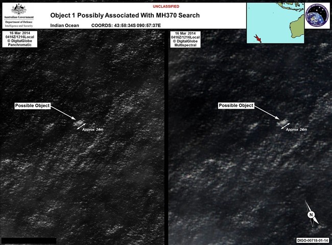
“We have been informed by an Australian government official that it was our imagery Prime Minister Abbott referred to in his recent comments,” said the statement.
“The satellite images were captured on March 16 by our WorldView-2 satellite at a resolution of approximately 50 cm,” their spokesperson told Global News in a separate email Thursday evening.
“No conclusions have been reached about the origins of the debris or objects shown in the imagery, and we are not aware that any subsequent search missions have been able to locate it,” their spokesperson said.
READ MORE: Australia spots possible plane debris, search to resume Friday
DigitalGlobe said it will continue to cooperate with authorities and provide any and all information at their disposal” to assist the search.”
On Friday, China said they were sending three warships to join the search in the southern Indian Ocean.
Australian Prime Minister Tony Abbott told Parliament earlier Thursday that “new and credible information has come to light in relation to the search for Malaysia Airlines flight MH370.”
“We must keep in mind that the task of locating these objects will be extremely difficult and it may turn out that they are not related to the search for flight MH370,” he said.
Flight MH370: What if missing plane is never found?


Just last week, the company asked the public to search for clues for the missing jet that disappeared without a trace more than a week ago and provided high-resolution images that were taken nearly 640 km (or 400 miles) above Earth.
The company made the images available on Tomnod, a website that encourages the public to sift through satellite images in order “to explore the Earth and solve real-world problems.”
READ MORE: Flight MH370: Thai Air Force says radar signal may have been missing plane
More than three million people joined the virtual party and began to scour the satellite images. Users are able to zoom in on every satellite image and tag a location with a “pin” if they believe they notice anything that could be part of the wreckage. If there is an overlap in tags, an algorithm will notify expert analysts if multiple people find something suspicious or noteworthy.
MORE: Flight MH370: frequently asked questions, few answers
According to the company, the experts would then notify authorities of any notable patterns or information that might lead to finding the missing jet.
It is unclear whether the objects that were found were identified by members of the public involved in the crowdsourcing project.
Objects found
One object is 24 metres (almost 80 feet) in length and the other is 5 metres (15 feet). Both have an indistinct, whitish appearance and are floating or just underneath the water surface.
The objects could be unrelated to the plane, possibly debris from ships, though the larger object is longer than a container.
These are the first objects identified as possible plane debris since the search was focused on the southern Indian Ocean.
This is not the first time the Tomnod website has been used to aid in a search. Last year, the map was used to help identify more than 60,000 objects of interest after Typhoon Haiyan struck the Philippines in November.
– with files from The Associated Press
Comments