

Global BC’s senior meteorologist is warning commuters to expect icy conditions on Thursday morning with more snowfall and a risk of freezing rain in the afternoon.

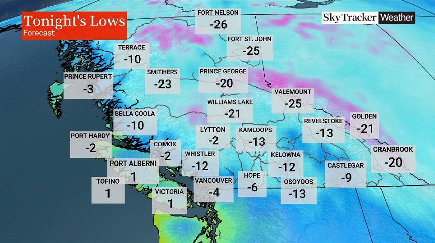
While snowfall will ease on Wednesday evening, temperatures are expected to drop to lows of -4 C in Vancouver, -6 C in Hope and -12 C in Whistler, according to Kristi Gordon.
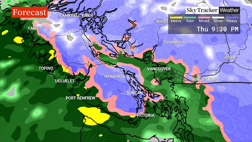
For Thursday, that means an icy morning commute. However, Gordon’s biggest concern is the afternoon commute, when there’s potential for more snow.
One to five centimetres are possible in the Fraser Valley and Metro Vancouver, while a heavier dump is forecast for Vancouver Island.

Get daily National news
The east coast of Vancouver Island is now under a snowfall warning, with 10 to 20 centimetres possible by Friday morning. A winter storm warning has also been issued for inland sections of the island near Port Alberni due to the possibility of another 15 centimetres of snow and windy conditions, followed by prolonged periods of freezing rain overnight.
- Calgary area ‘very uniquely situated’ for study of hailstorms, says researcher
- Saskatchewan boosts disaster aid in response to storm-packed spring and summer
- Flooding damage closes Telus World of Science for months, 68% of staff laid off
- Wildfire smoke transforms skies as air quality plummets across Canada


The rest of the South Coast has a risk of freezing rain between Thursday afternoon and night. Temperatures will warm up late Thursday evening, meaning rainfall expected overnight as well, Gordon said.
About 20 regions of British Columbia are currently under Environment Canada weather warnings for conditions including snowfall, winter storm, and arctic outflow.
On Wednesday, the federal agency confirmed 29 centimetres of the white stuff had fallen in Abbotsford — the greatest amount in the Lower Mainland — while Victoria and North Courtenay saw the greatest amount on Vancouver Island, at 19 centimetres.
Members of the public are urged to stay home where possible and take precautions if they must be outside, including dressing warmly and leaving extra distance between vehicles if driving.
Comments
Want to discuss? Please read our Commenting Policy first.