

Saskatoon’s record breaking heat streak comes to an end!

Saskatoon Forecast
Today
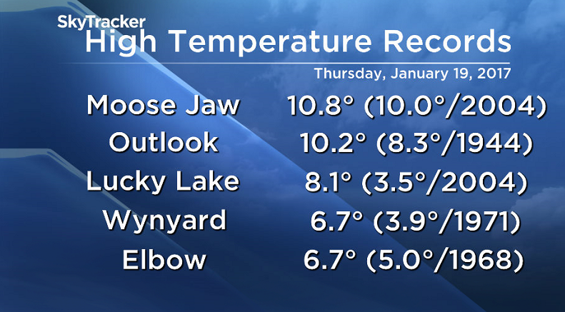
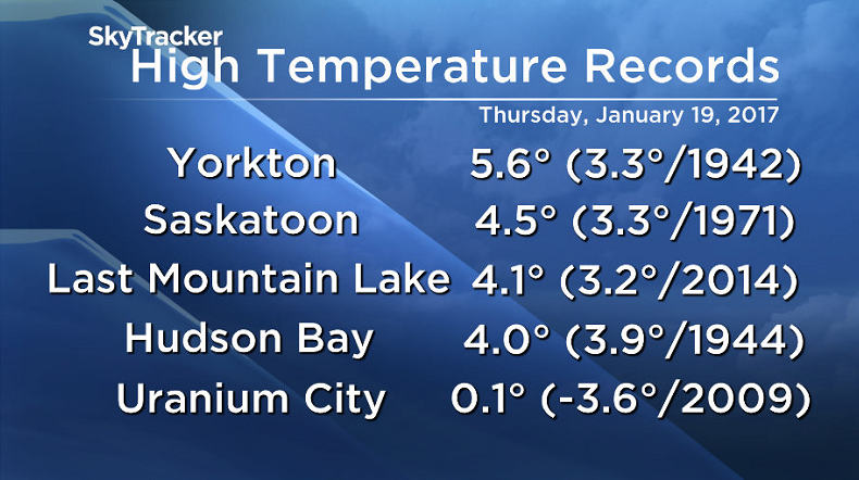
It was the warmest Jan. 19 in recorded history in Saskatoon, breaking a 46-year-old record with a daytime high of 4.5 degrees, breaking out previous record of 3.3 from 1971.
Twenty-one high temperature records were broken across Saskatchewan on Wednesday, 13 were shattered on Thursday across the province.
READ MORE: 94-year-old record broken in Saskatoon as historic heat streak continues
Saskatoon started off the day just below the freezing mark with wind chill values in mid-minus single digits under mostly cloudy skies.
That high cloud will stick around this afternoon with the mercury pushing up to around 2 degrees.
Normally the city sees four days with above freezing temperatures in January, which is exactly how many days we have seen this week and so far this month.

Tonight
Cloud cover will continue tonight as temperatures drop down to -3.
Saturday
-8 is around what it’ll feel like with wind chill to kick off the weekend under cloudy skies.
Light snow is expected to begin midday and continue into Sunday with 2 to 4 centimetres likely as temperatures sit just below the freezing mark through the day.

Sunday
Cloudy skies will stick around on Sunday with light snow likely to linger into the day as upper level instability keeps conditions unsettled.


Temperatures will cool a little further with an afternoon high around -2 expected.

Work Week Outlook
An upper trough will hangout over the region into the work week keeping conditions mostly cloudy with a slight chance of flurries before we get into some sunny breaks by the middle to the end of the week.

Cooler air will press in with daytime highs back into mid-minus single digits and lows dropping back into minus double digits.
Lisa Diewold took this Your Saskatchewan photo at Buffalo Pound Lake:

READ MORE: Get a 2017 Your Saskatchewan calendar today
Saskatoon weather outlook is your source for Saskatoon’s most accurate forecast and is your one stop shop for all things weather for central and northern Saskatchewan with comprehensive, in depth analysis that you can only find here.
- Roll Up To Win? Tim Hortons says $55K boat win email was ‘human error’
- Bird flu risk to humans an ‘enormous concern,’ WHO says. Here’s what to know
- Halifax homeless encampment hits double capacity, officials mull next step
- Ontario premier calls cost of gas ‘absolutely disgusting,’ raises price-gouging concerns
Comments