
UPDATE: All advisories mentioned in this story have ended

SASKATOON – After a dose of snow made its mark Family Day weekend, extreme cold make its presence known this weekend. An arctic high pressure system is crashing in from the north and will sit over Saskatchewan ushering in extreme cold through the entire weekend.
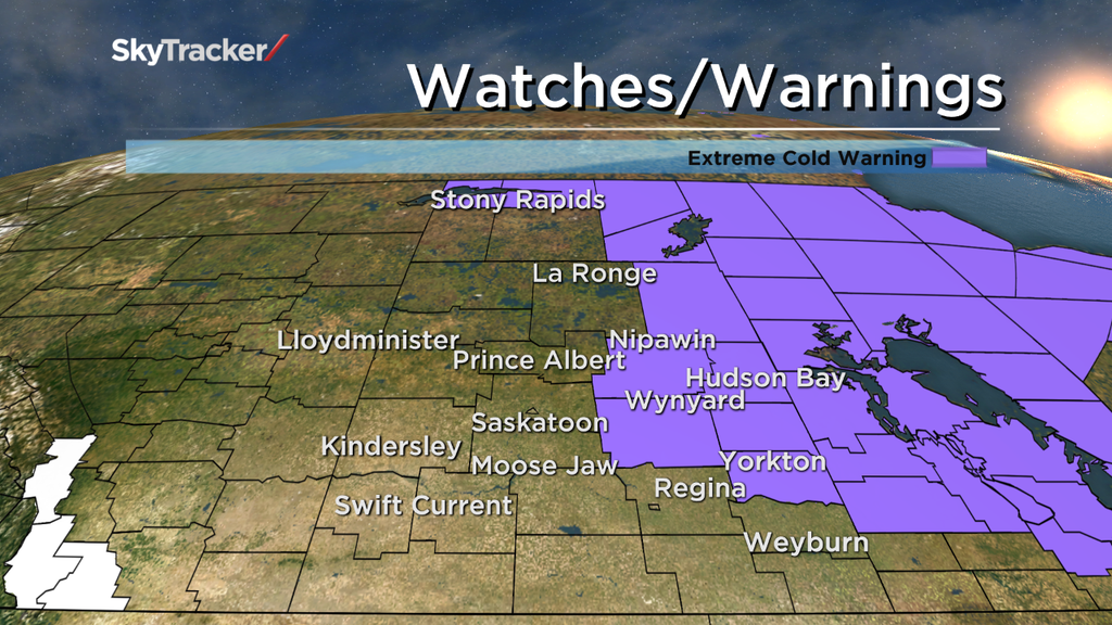
Extreme cold warnings have been issued by Environment Canada for parts of east-central Saskatchewan including the Melfort, Wynyard, Yorkton and Humboldt areas for wind chill values of minus 40 expected overnight into Saturday morning.
Wind chill values are expected to moderate during the day Saturday above extreme cold warning criteria, but extreme wind chills are expected to redevelop Saturday night into Sunday morning.
This time the extreme cold warning will likely span a larger portion of the province and will likely include the City of Saskatoon.
Temperatures in Saskatoon are expected to drop into the mid-minus 20s Saturday morning with wind chills in the mid-minus 30s, but Saturday night into Sunday morning temperatures will fall back into the minus 30s with wind chill values into the minus 40s.
Environment Canada issues extreme cold warnings for central and southern Saskatchewan when either the temperature or wind chill values drop to minus 40 or lower.
For an extreme cold warning to be issued in northern Saskatchewan, temperatures or wind chill values must reach minus 45 or lower.
- Toronto Pearson gold heist: Ontario man arrested at airport after arriving from India
- Capital gains changes could have ‘irreversible’ effects, business groups warn
- Renters so far more ‘vulnerable’ than homeowners amid higher interest rates. Why?
- After tornado outbreaks in the U.S., could Canada see similar storms?
Extreme cold warning are also in place Friday night for parts of extreme northern Saskatchewan with overnight lows dropping below minus 35, winds near 15 km/h giving wind chill values between minus 45 and minus 50 into Saturday morning.
Extreme cold warnings are issued when very cold temperatures or wind chills create an elevated risk to health such as frost bite and hypothermia.
Wind chill describes the felt decrease in air temperature on exposed skin caused by air flow. It is important that humans are aware of wind chill values because extreme cold conditions can cause frostbite, which is the freezing of skin.
At extreme wind chill values skin can freeze in a matter of minutes.
Want your Saskatoon and area weather on the go? Download the Global News SkyTracker weather app for iPhone, iPad or Android.
Extreme cold warning ENDED for:
- Regina
- Melfort – Tisdale – Nipawin – Carrot River
- Humboldt – Wynyard – Wadena – Lanigan – Foam Lake
- Pelican Narrows – Cumberland House – Creighton
- Fond-du-Lac – Stony Rapids
- Wollaston Lake – Collins Bay
- Southend – Brabant Lake – Kinoosao
- Yorkton – Melville – Esterhazy
- Hudson Bay – Porcupine Plain
- Kamsack – Canora – Preeceville
- Carlyle – Oxbow – Carnduff – Bienfait – Stoughton
- Cree Lake – Key Lake
- Estevan – Weyburn – Radville – Milestone
- Fort Qu’Appelle – Indian Head – Lumsden – Pilot Butte
- Moosomin – Grenfell – Kipling – Wawota
- Uranium City – Camsell Portage
- Melfort – Tisdale – Nipawin – Carrot River
Comments