
Weather update: Thursday December 18th 5am

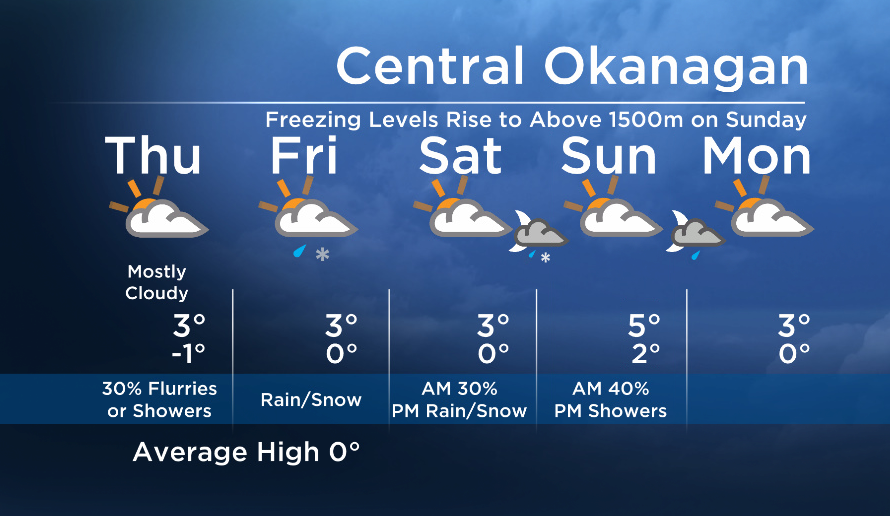
Some of us woke up to a centimetre or two of snow this morning, and there is more snow in the forecast tonight.
An upper ridge will keep the next system from moving inland until tonight, so expect a mostly dry but cloudy start to the day and precip will move in again this evening.
With freezing levels around 700m, most areas will see snow. However, by Friday afternoon freezing levels will be close to 1000m, so we will see a mix of rain and snow in parts of the valley tomorrow, and there will be snow on the local ski hills and mountain passes.
Expect a short break for Saturday, but then another wave of rain/snow will move in on Saturday night.


A switch to a westerly flow aloft this weekend will also bring in some milder air, and daytime highs will stay above seasonal over the next several days.
See you at 5, 6:30 and 11pm tonight!
Today’s Highs: 0 to +4C
~Wesla/Duane
- Suspect in killing of temple leader Hardeep Singh Nijjar got student visa in ‘days’
- Panera to remove ‘Charged Sips’ drink from Canada amid wrongful death lawsuits
- Minister Boissonnault to testify before ethics committee over ties to lobbyist, PPE company
- ‘Summer of discontent’ coming over public service in-office order: unions
Comments