
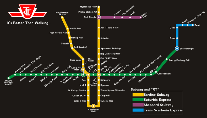
ABOVE: Parody map of Toronto shows off Toronto’s diverse identity. Peter Kim reports.

TORONTO – Commuter Hell, Suits & Ties, Evil ‘LRT’ Here, and Times Square Wannabe are just some of the crude attempts at renaming TTC stations on a map lampooning the commission’s well known “Ride the Rocket” map.
In case you’re wondering, the above stations replace Union Station, King and St. Andrew, St. Clair East and Dundas (Yonge/Dundas Square).
The map was posted on the Reddit.com subreddit /r/toronto on Tuesday by a user dubbed ‘TXTCLA55’ and has since gone viral among Torontonians, receiving over 800 upvotes and dozens of shares on Facebook.
The map renames all of the TTC’s stations with names the author seems to believe describes their respective neighbourhood.
Bay Street station has been renamed “$$$”, Dupont Station has become “The Annex”, Lawrence Station changed to “Am I There Yet?!” and Kipling Station – the Bloor-Danforth line’s most westward stop—has been renamed “Where The Hell Am I?”
The map is also politically timely, using Mayor Rob Ford’s criticism of streetcars on St. Clair Avenue as the supposed inspiration behind the subway station being renamed “Evil LRT Here.”
What do you think of the renamed TTC Stations? Join the discussion on the Global News Facebook page and let us know.
While the map was possibly made in jest, it has found detractors online. One Reddit user, Arachnih, suggested the creator of the map was “not from UofT if Queen’s Park is the only station that means UofT to you.”


And another map, created by design company Urbane, parodies the neighbourhoods of Old Toronto (South of Bloor between Pape in the east and the Junction to the west).

Though Urbane is not local to Toronto, its map shares some similarities with the TTC map.
Urbane’s map also characterizes much of downtown between King Street Station, Union Station and St. Andrew as “Suits and Ties.”
And Yonge and Dundas Square is renamed “Times Square, Almost.”
City Hall is described simply as “WTF, Mayor Ford.”
And a section of Queen Street West is deemed Toronto’s “Hipster Mecca.”
Urbane has also created similar maps for Manhattan, San Francisco and Los Angeles.
- S&P/TSX composite down, U.S. markets mixed ahead of tech earnings and economic data
- Big warm-up to follow blast of cold air in southern Ontario
- 1 deal falls through but Toronto FC completes another in Derrick Etienne Jr. trade
- No more sick notes? Why the Ford government wants to eliminate doctors notes for illness
Comments