
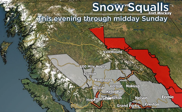
Several regions in B.C. are under weather warnings Saturday and Sunday, with alerts for heavy snow and snow squalls stretching from the Fraser Valley to the South Cariboo to the Kootenays.

According to Environment Canada, a Pacific frontal system is expected to bring heavy snow into those areas, with mountain passes receiving 20 to 25 cm by Sunday morning.
Affected mountain passes include the Trans-Canada Highway (Eagle Pass to Rogers Pass), Coquihalla Highway (Hope to Merritt) and Highway 3 (Hope to Princeton; Paulson Summit to Kootenay Pass).
Read more: Thundersnow: why it happens and how it forms
“A cold front will move through the B.C. Southern Interior this afternoon, bringing colder temperatures and leaving the region favourable for snow squalls to develop starting this evening,” said Environment Canada.
“There is also a potential for thundersnow late this afternoon and early this evening.”
The national weather agency says when a snow squall develops, localized areas will see a brief period of heavy snow with near-zero visibility.

Get daily National news
Global News weather anchor Kasia Bodurka says thundersnow is a rare occurrence and happens behind a cold front, which tend to create convective weather.
And when two air masses collide, as what often happens with cold fronts, thunderstorms can result. The greater the difference in air masses, the stronger the storms.

Regions under special weather statements for snow squalls include:
- Old Man Winter wallops B.C.’s Mainland/Southwest region, major highway closed
- Calgary hit by unexpected blast of spring snow, causing dozens of crashes
- False spring strikes again: Saskatchewan prepares for incoming winter weather
- Albertans’ interest in alternative forms of travel growing as fuel prices spike


- Fraser Canyon
- Lillooet
- Nicola
- 100 Mile House
- Chilcotin
- South Thompson
- North Thompson
- Central Okanagan
- North Okanagan
- Shuswap
- West Columbia
- West Kootenay
- Kootenay Lake
- East Kootenay
- Elk Valley
The snow is expected to taper off to a few flurries on Sunday.
An alert for heavy snow is also in place for the South Peace River region, where 10-15 cm is expected courtesy of an Arctic front moving across the area. Temperatures are also expected to be 10-15 degrees below normal.
Slightly to the west, in the Williston region, a special weather statement is in effect for heavy snow, along with wind gusts of up to 50 km/h. Temperatures are expected to fall by 10 degrees.
And, lastly, a wind warning is in effect for Victoria, with gusts of 50 to 70 km/h expected, though they could reach 90 km/h near Juan de Fuca. The winds are expected to lessen after midnight.

Comments
Want to discuss? Please read our Commenting Policy first.