

The winter storm warnings for London and Middlesex region may be gone, but the snow and gusty winds aren’t done with us yet, forecasters with Environment Canada say.

This after the region was hit by rain, freezing rain, and then snow Thursday into Friday, resulting in poor driving conditions, localized flooding, and dozens of collisions on roadways across southwestern Ontario, according to provincial police.
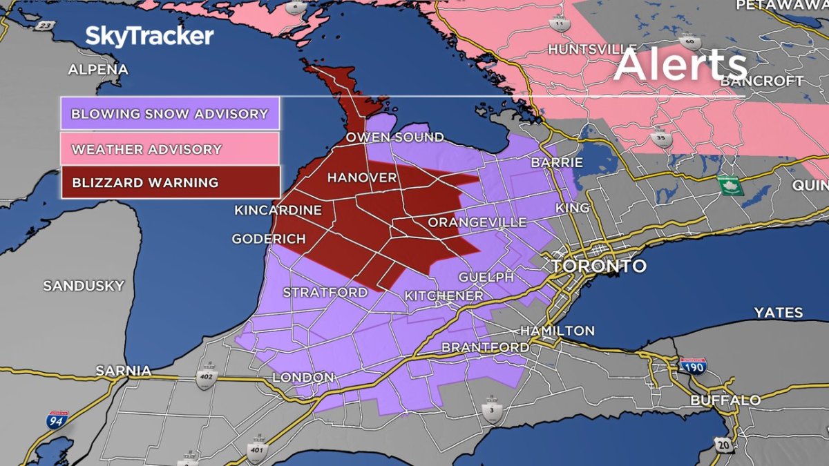
At least two to four centimetres of snow are expected to fall in the London region overnight into Saturday, forecasters with the national weather service say.
More concerning, however, are the strong 70 to 80 km/h gusts that are expected to roll through the region early Saturday, leading to blowing snow and significant reductions in visibility.
Temperatures Friday night are expected to feel like -14 Friday evening, -19 C overnight, and -22 C Saturday morning, Environment Canada says, while Saturday afternoon is expected to feel like -14 C.
A blowing snow advisory has been issued for London and Middlesex as a result, and blizzard warnings are in place for northern Huron and Perth counties.
The forecast wintry conditions are the result of an incoming weather system tracking eastward from the Prairies, said Environment Canada’s Gerald Cheng.
The predicted snowfall comes on top of the dumping of snow the region received Thursday night and Friday morning, brought on by a warmer system from the south and southwestern U.S. which tracked northeast across the lakes.
“It was a really incredible system because we had everything. We had rain, we had freezing rain and then snow, and then this morning, lake effect snow behind the system,” Cheng said.
“It was mild and then suddenly the temperatures came crashing down on Thursday, and that’s why the rain switched to freezing rain … (which) lasted about, I would say, more or less of five hours.”
In all, roughly 14 centimetres of snow was recorded at London’s airport as a result of the system, along with an additional 11 centimetres of lake effect snow that followed afterward, he said.
The messy weather Thursday into Friday resulted in a flurry of collisions and closures on area roadways, and prompted several flood advisories from local conservation authorities.
In London, police said officers responded to 11 collisions overnight, while 23 collisions were reported to the police reporting centre.
Out of the city, OPP say at least 193 collisions were reported on roads across southwestern Ontario between 5 p.m. Thursday and 2:30 p.m. Friday, mostly minor in nature, said Acting Sgt. Ed Sanchuk.
“Just around 5:30-6 a.m., we had about four collisions on the go. After about 7 to 8 a.m., that’s when we started seeing a little bit of issues on the 401 and 402,” he said.
“We did have the 402 closed eastbound and westbound from Middlesex down to Lambton for quite a few hours as we continued to clean up crashes that occurred.”
The highway has since reopened, however Sanchuk stresses that motorists should drive according to the conditions, especially since more snow is in the forecast.
“Make sure you’re checking over your shoulder twice, you’ll save a life. Make sure your entire head lighting system’s on,” he said.
“But more importantly, you need to reduce your speed, pay to 110 per cent your driving ability, and just please — not to sound like a broken record — slow down so you get home safely to your family.”


Flood warnings remained in place Friday afternoon from several area conservation authorities, including Catfish Creek Conservation Authority, which covers parts of Elgin County including Aylmer and Port Bruce, and Long Point Region Conservation Authority.
Officials with Malahide Township issued an evacuation notice for residents of Port Bruce Thursday afternoon as a result of significant flooding in the community. An evacuation centre was set up at Sommerfeld Church in Mount Salem.
“Port Bruce remains under an evacuation. The water levels remain high and are expected to recede later today,” the township said in a Facebook post Friday morning. “Entry points to the Village remain closed for non-essential access.”
In an update posted shortly after 3:30 p.m. Friday, officials said road access to the community was “slowly returning to normal” and that water was receding.
“Public Works has been working continuously to remove large chunks of ice and other material obstructing the roadways,” the post read. “Residents are advised to utilize strict caution if and when returning to their properties and dwellings.”
High water levels and ice jams were reported in Port Stanley, resulting in flooding and the closure of one of the town’s main crossing points across Kettle Creek.
Officials with Elgin County say the King George Lift Bridge will remain open throughout the weekend “due to ongoing concerns with high creek water levels and ice flow.”
Kettle Creek Conservation Authority had issued a flood watch on Wednesday. Elsewhere, flood watches were issued by the Lower Thames and Upper Thames conservation authorities.
Officials with Lower Thames later downgraded the watch on Friday to a watershed condition statement.

Comments