

Many parts of B.C. will be welcoming 2022 with another winter storm.

Environment Canada has issued a warning for the north and central coast, Howe Sound, parts of the north coast and Whistler.
A winter storm watch is also in effect for parts of the Fraser Valley and Metro Vancouver.
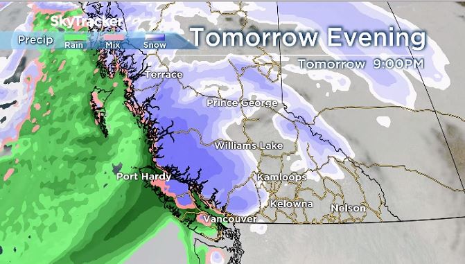
Global BC meteorologist, Yvonne Schalle, said the next weather system is on deck for New Year’s Day. It will rapidly spread down the coast and inland Friday night and into Saturday.
Coastal areas could again see heavy snow, rain and strong winds, Schalle said and light snow will then be moving onto northern Vancouver Island.


Get breaking National news
“A well-defined and strengthening frontal system will take over this weekend,” Schalle said.
In Metro Vancouver and the Fraser Valley, flurries will begin Saturday morning and then periods of snow or rain will develop and intensify during the day, she added.
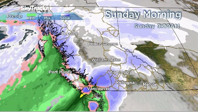
Between two and 10 centimetres of snow is possible for Saturday, with higher amounts expected near Hope. There will also be a risk of freezing rain overnight Saturday into Sunday with the potential for 10 to 40 millimetres to fall on Sunday, Schalle said.
It is expected there will be milder temperatures and more rain on Sunday along with strong winds for most of the weekend, Schalle added.
Metro Vancouver and western sections of the Fraser Valley will transition to rain Sunday, while areas closer to Hope will get more snowfall, according to Environment Canada.
Additionally, there is a risk of freezing rain as warm air overrides the cold air near the surface.


For east Vancouver Island, a special weather statement has been issued due to snow with the risk of freezing rain from Saturday to Sunday morning.
Periods of snow will begin overnight or Saturday morning and will then change to rain late in the day as freezing levels rise. However, over the inland sections, and the higher terrain of Vancouver Island, snow is likely to continue into Sunday morning, Environment Canada said.
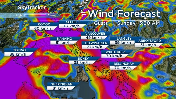
A wind warning has also been issued for east Vancouver Island, Nanoose Bay to Fanny Bay, Courtenay to Campbell River and from Saltery Bay to Powell River on the Sunshine Coast. On Saturday night, strong winds may cause damage with gusts between 70 km/h to 90 km/h.
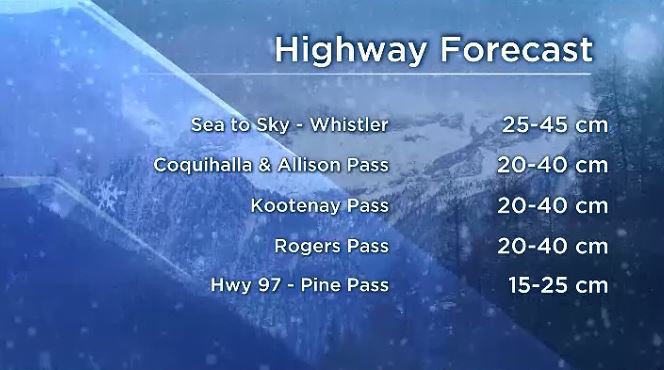
Motorists are warned that heavy snow is expected on mountain passes this weekend.
Environment Canada’s special weather statement indicated 15 to 30 centimetres of snow is expected for Highway 3 from Hope to Princeton via Allison Pass and Paulson Summit to Kootenay Pass, the Coquihalla Highway from Hope to Merritt, and the Trans-Canada Highway from Eagle Pass to Rogers Pass.
Comments
Want to discuss? Please read our Commenting Policy first.