KELOWNA — Sunday August 18th marks the 31st annual Kelowna Apple Triathlon.

Road closures and detours are in effect during the day to accommodate the event.
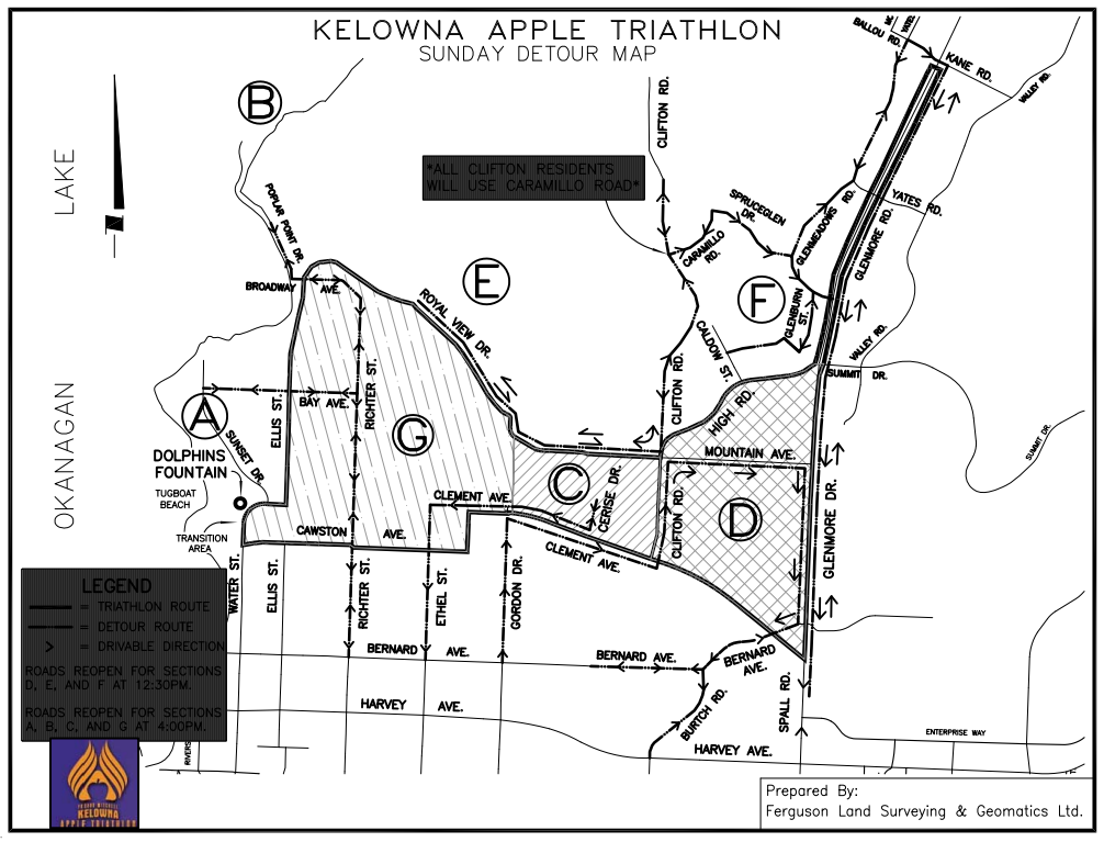
Here is the list:
Sunday (6:00 am until 1:00 pm)
Road & Boat Launch Closures
– Water St from Dolphins Fountain to Queensway (west side only)
– Queensway from Water to Bernard (north side only)
– Bernard from Queensway to Abbott (north side only)
– Abbott St from Bernard to Hwy 97 (west side only)
– Clement from Dolphins Fountain to Ellis
– Ellis St from Clement to Knox Mtn
– Royal View from Knox Mtn to Mt Royal (south side only)
– Mt Royal & Mountain (from Royal View to Skyline/Clifton)
– Skyline/Clifton (from Mountain to High)
– High (from Skyline/Clifton to Glenmore)
– Glenmore from Ballou/Kane to Clement (west side only)
– Clement from Spall to Graham (north side only)
– Graham from Clement to Coronation
– Coronation from Graham to St Paul
– St Paul from Coronation to Cawston
– Cawston from St Paul to Water
– Rose’s Boat Launch & Parking Lot
– Queensway Boat Launch
– Ellis St north end boat launch
– Grand Lagoons boat locks

Detours
– Sunset and Manhattan (Map Zone A) – Use Bay Avenue – Richter – Hwy 97
– Poplar Point (Map Zone B) – Use Broadway – Richter – Hwy 97
– North End (Map Zone G) – Use Richter or Ethel – Hwy 97
– Cerise Area (Map Zone C) – exit via Clement – Ethel – Hwy 97 return using Gordon – Clement – Cerise.
– Old Glenmore (Map Zone D) – exit area using Glenmore – Bernard. Return using Gordon – Clement – Clifton. Note: you may also use Bernard – Dilworth Crescent to enter or exit
– Mt Royal, Mountain & Clifton (Map Zones E & F) – Use Glenmeadows – Yates – Kane to reach Glenmore Road
– Eldorado Boat Launch is open
- Surrey hospital won’t have emergency team for parts of May long weekend, doctor claims
- Vancouver Island residents question new supportive housing location
- B.C. daycare operator says provincial red tape could close facility
- Canada to race in first-ever women’s America’s Cup with Vancouverite at the helm
Comments