
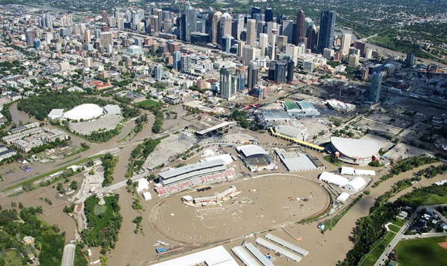
TORONTO – Social media users along with Internet giant Google are continuing efforts to restore everyday life to the thousands of Calgarians who remain displaced due to record flooding.

Google’s Crisis Response Team released a Crisis Map Saturday showing evacuation zones, emergency shelter locations, public alerts and even traffic conditions of all affected areas of Alberta, including Medicine Hat – the latest area to be affected by flooding.
Water levels on the South Saskatchewan River peaked around 1 a.m. local time on Monday, but it is believed that flooding in the area won’t be as severe as initially feared.

Get breaking National news
Meanwhile in Calgary, residents are still being advised to stay out of the downtown core Monday and Tuesday as clean-up efforts begin.
- Cineplex slapped with record $38.9M fine over online booking fee
- Conservatives set to table non-confidence motion Tuesday. What to expect
- After controversial directive, Quebec now says anglophones have right to English health services
- Home reno spending was up $300B over pandemic, Re/Max Canada says


“Our thoughts remain with everyone in Alberta affected by these floods, and with the many officials and first responders throughout the province whose resilience has united us all and will guide the recovery effort,” read a post on Google Canada’s blog.
Google’s Crisis Map uses open data from local communities, as well as the province of Alberta, to curate local-specific information as clean-up efforts continue.
Residents are even able to see re-entry centres as well as the hydrology of some areas on the map.
But efforts to restore the resilience of Calgary’s people – along with the familiarities of everyday life – are well underway on all channels of social media.


Calgary’s page on popular social networking site Reddit has become a hotbed for user curated information about road and bridge closures, as well as photographic updates showing progress of the water receding.
Read More: Social media users offer dry clothing, places to stay for flood evacuees
Users posted information about transit closures, to what stores had bottled water in stock.
But the site has also generated a number of posts from users offering support, or thanking residents and organizations for small gestures during Calgary’s time of need – including one post which showed an empty tray of treats donated by a bakery.
A user from Madrid even left a message on Calgary’s subreddit /r/Calgary with a message titled, “if you know any families with children who are still in a mandatory evacuation zone, PM me I would like to send them something cool in the mail.”
Elsewhere on the web, Calgary’s Kijiji page reads more like a humane society than a classifieds website.
Users have taken to posting ads for lost and found animals in the aftermath of the flooding.
Comments