

A bit of light rain kicked off the day in southern B.C. early Thursday before the showers eased up and the mercury fell back to 12 C.

Sunny breaks are expected to start working their way back in across the valley later in the day as the mercury rises into the 17 C range in the afternoon.
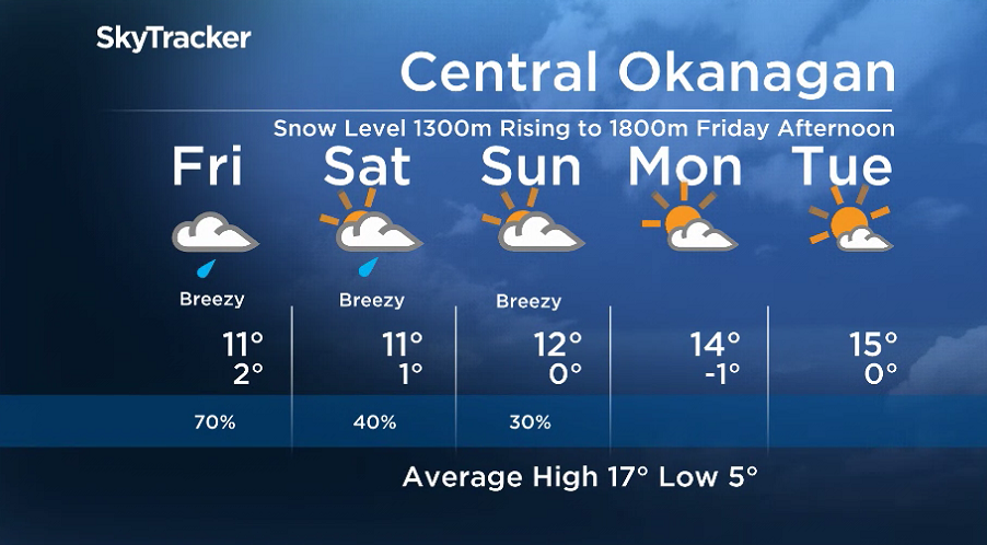
An upper-level low-pressure system is expected to bring clouds, showers and the risk of high-elevation snow to the area by early Friday morning.
Freezing levels will sit around 1,300 metres to start the day, with rain falling in the valley.

Get daily National news
Upwards of 10 to 20 centimetres of snow is expected to fall throughout Friday and into early Saturday along the Okanagan Connector.


Snow is also expected in slightly smaller amounts along Paulson Summit, Kootenay Pass, Allison Pass, Rogers Pass and along part of the Coquihalla Highway between Hope and Merritt, with gusty winds possible throughout all parts of the southern Interior into the weekend.
Drivers should have winter tires that are marked with either “M+S” or the mountain-and-snowflake symbol before travelling on any high-elevation travel routes on Friday or Saturday.

Rain in the bottom of the valley will put a damper on daytime heat on Friday with the afternoon high only getting up to 11 C. Temperatures will also top out around the same number on Saturday, when there will be spotty showers.
Mostly cloudy skies are expected to linger with a slight chance of showers on Sunday as the mercury makes it up a degree further to around 12 C.
September ends and October kicks off on a sunnier note next week, with daytime highs returning to the teens.
For weather on the go, download the Global News SkyTracker Weather App for iPhone, iPad or Android.
Comments
Want to discuss? Please read our Commenting Policy first.