
Record heat was reached in the Central and North Okanagan as spring kicked off on Wednesday afternoon at 2:58 p.m. PT.

Kelowna broke a record high of 16.2 degrees from 1988, as the mercury rose up to 16.4. Vernon also eclipsed a 104-year-old record of 15.6 from 1915, as temperatures swung up to 15.8.
The major melt in the valley bottom continued into Thursday, as temperatures quickly sprung up from -1 in the sun to double digits before noon, with an afternoon high hopping back into the mid-teens.

Get breaking National news
After a sunny first full day of spring on Thursday, the work week will finish on a mostly sunny note on Friday, before clouds start building in during the afternoon as thermometers climb from -1 to 15 degrees.
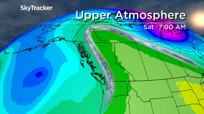
A frontal boundary pushing through will bring in a chance of showers Friday evening, with snow above 2,000 metres.


The chance of showers continues into the day on Saturday before some late-day clearing starts to slide in after climbing to a daytime high around 11 degrees.

Sunday will be similar with mostly cloudy skies moving in, along with a chance of showers as temperatures struggle to get into double digits during the day.
Freezing levels will fall from 2,500 metres on Thursday to 2,000 metres on Saturday, and then down into the 1,000- to 1,500-metre range by Sunday morning, with snow expected at higher elevation areas.
Partly-to-mostly cloudy skies then return for the final week of March, with a chance of showers mid-week as afternoon highs settle into seasonal values, poking up into double digits by a few degrees.

For weather on the go download the Global News SkyTracker Weather App for iPhone, iPad or Android.


Comments