

-40 to -50 wind chills return to finish February.

Extreme cold warning
Environment Canada has continued an extreme cold warning for Saskatoon, Regina and all of central and southern Saskatchewan.
Extreme wind chill values of -40 to -50 that kicked back in over the weekend continued into the day on Monday and will last into Tuesday despite some easing during the day.
Be sure to dress warmly and in layers as frostbite can develop within minutes on exposed skin.
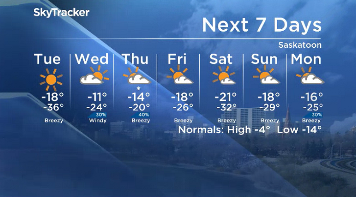
Saskatoon forecast
Monday
-47 is what it felt like in Saskatoon to kickoff the final week of February Monday morning as temperatures dove back to -35 degrees, close to breaking a record low of -37.8 from 1893.
Clear skies and sunshine kicked off the day and helped warm conditions up with the mercury making it up into the -20s before noon.
A breezy southwesterly wind picking up during the afternoon helps boost thermometers up even further toward the 20-degree mark with wind chills still in the -30s as sunny skies stick around all day.

Get breaking National news
Monday night
An arctic high-pressure system over the province will keep skies clear through the evening as temperatures plunge back into the mid -30s overnight.
Tuesday
-48 is around what it’ll feel like Tuesday morning with wind chill, which means exposed skin can freeze in mere minutes, however, wind chills should recover into the -30s as temperatures climb to -19 during the day.
Beautiful blue skies and sunshine will be back as well right through the day with a chance of a few late day clouds building in as a gusty southwesterly wind picks back up, helping to warm things up.


Wednesday-Friday
Clouds from an upper trough finally return mid-week to help warm the region up for the final few days of February before arctic air surges back in to kickoff March.
Clouds will come with a chance of flurries Wednesday and Thursday before some clearing on Friday as daytime highs make their way into the minus teens with overnight lows staying in the -20s.

Weekend outlook
Arctic air surges back in Saturday morning, dunking daytime highs back into the -20s and bringing in another -30 overnight low before temperatures nudge up a bit on Sunday under a mix of sun and cloud.
Suzanne Gauthier took the February 25 Your Saskatchewan photo in Meota:

Saskatoon weather outlook is your source for Saskatoon’s most accurate forecast and is your one-stop shop for all things weather for central and northern Saskatchewan with comprehensive, in-depth analysis that you can only find here.
For weather on the go, download the Global News SkyTracker Weather App for iPhone, iPad or Android.
Comments
Want to discuss? Please read our Commenting Policy first.