
Finally some relief rolled in from the bone dry, hot conditions that plagued the Okanagan throughout most of August so far.

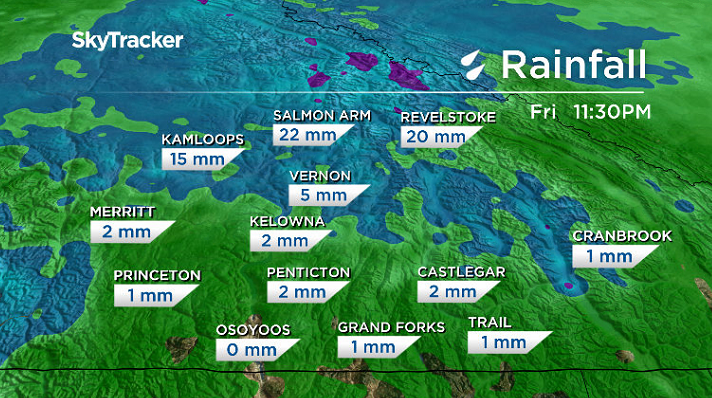
It came in the form of rain over the weekend with 4.2 millimetres falling in Kelowna, which helped wash out the smoke and clean the air.
Air quality improved to a low health risk to start the week; however, Environment Canada continued a special air quality statement for the area for potential for conditions to worsen and smoke to return.
The reason for that is the fact that fire activity remains widespread across the province, which means that communities downwind of wildfires may continue to see poor air quality at times.


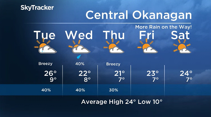
After a glorious sunny Monday with temperatures bumping back into the low 20s, clouds will back in Monday night and stick around into Tuesday with a chance of a few showers to start the day.

Get breaking National news
That risk will diminish in the afternoon as clouds clear out and sunshine returns to wrap up the day along with a daytime high in the mid-20s.
Another surge of clouds comes on Wednesday with a decent chance of rain once again during the day, as an upper trough swings through, knocking daytime highs back into the low 20s.

The rain risk will lessen on Thursday with some lingering clouds and a few breaks of sunshine possible with temperatures once again stuck in the low 20s.
The mercury rebounds heading into September long weekend with daytime highs jumping back into the mid-20s Friday and Saturday with increasing sunshine before they slip back a bit into the low 20s into Labour Day Monday.
For weather on the go download the Global News SkyTracker Weather App for iPhone, iPad or Android.
Comments
Want to discuss? Please read our Commenting Policy first.