
Efforts in battling the latest fire burning near Peachland and Summerland is going well, according to the B.C. Wildfire Service.

“The Darke Creek fire has 21 personnel on site today who are being supported by helicopters,” said BCWS information officer Shelley Zupp. “Three quarters of this fire has hose-lay around it and it’s responding well to suppression efforts.”
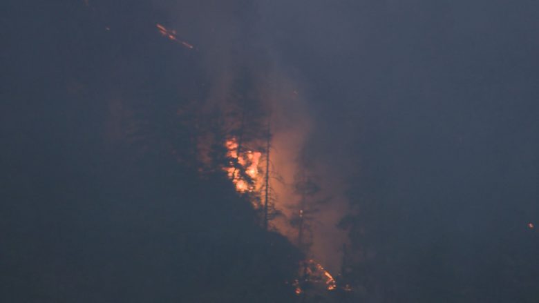
The fire, which sparked to life on Monday, is estimated at 4.8 hectares and is located in the Darke Lake Provincial Park area, approximately 16 kilometres northwest of Summerland or 12 kilometres southwest of Peachland.
On Monday, at 6 p.m., the Regional District of the Okanagan-Similkameen issued an evacuation alert for the provincial park and 21 nearby properties.
“The RDOS is aware that residents in this area were put on evacuation alert exactly one month ago due to the Mount Eneas fire,” the regional district said in a press release. “We can appreciate how the high activity of wildfires and the amount of smoke in the area can make residents feel uneasy. We want to thank all residents for preparations and patience during this time.”
Below is a list of notable fires in the Okanagan, Similkameen and Boundary regions:

Get daily National news
OKANAGAN
Bear Paw Creek
- Location: 17 kilometres west of Summerland.
- Size: 4.7 hectares.
- Status: Active, new, but 100 per cent machine guarded.
Darke Lake Valley
- Location: 12 kilometres northwest of Summerland.
- Size: Approximately 5 hectares.
- Status: Active, new.
Mount Gottfriedsen


- Location: Pennask Mountain, near Highway 97C, 24 kilometres west of West Kelowna.
- Size: 633 hectares.
- Cause: Lightning.
- Status: Active, but classified as under control. One hundred and 28 personnel on site, which includes 100 military personnel, along with four pieces of heavy equipment.
- BCWS notes: “Low temperatures and high relative humidity saw a significant reduction in fire activity. Successful integration of Canadian Forces with existing crews occurred yesterday. With the fire now under control, all resources will be focussed on mop up operations allowing other resources to be re-deployed to other incidents. Crews have achieved 100-foot mop up depth for 95 per cent of the fire perimeter. Crews are achieving 200-foot depth in patches of green timber.”
Harris Creek Forest Service Road
- Location: 16 kilometres southeast of Lumby.
- Size: 508 hectares.
- Cause: Lightning.
- Status: Active, classified as out of control. Thirty-nine personnel on site along with nine pieces of heavy equipment. Helicopters are available to support ground crews on this wildfire; however, their use is dependent on flying conditions.
Sugar Mountain
- Location: Four kilometres east of Sugar Lake.
- Size: 394 hectares.
- Cause: Under investigation.
- Status: Active, classified as out of control. Zero personnel on site.
- BCWS notes: “An area restriction order was put in place on August 4 and remains in force until the earlier of 12:00 noon on September 15 or until the order is rescinded. The order is for crown land in the vicinity of Sugar Lake (west of Sugar Lake). This order was put in place to address a public safety concern arising from the Sugar Mountain wildfire and in order to avoid interference with fire control.”
Mabel Creek
- Location: Six kilometres east of Mabel Lake.
- Size: 1,861 hectares.
- Cause: Under investigation; suspected lightning caused.
- Status: Active, classified as out of control. Twenty-three personnel on site with five helicopters and eight pieces of heavy equipment. An area restriction order is in place for crown land in the vicinity of Mabel Lake.
- BCWS notes: “The area restriction includes a road closure along the Mabel Lake FSR to all recreation traffic from kilometre 10 (north the Mabel Lake Provincial Park) to km 59 (at the junction of Highway 1) and all recreation sites along that road. The closure does not apply to the residents in the Mable Lake Holdings community, nor other private residences along the Mabel Lake FSR. These closures are not due to fire threat but for road safety for our crews and industry partners traveling to and from the fires.”
Whip Creek
- Location: Three kilometres south of Mabel Creek wildfire
- Size: 504 hectares.
- Cause: Lightning.
- Status: Active.
Juliet Creek
- Location: 47 kilometres southwest of Merritt.
- Size: 868 hectares.
- Cause: Lightning.
- Status: Active. Eighty-seven personnel on site along with 13 pieces of heavy equipment. Air support available as needed.
- BCWS notes: “Today crews will continue mop up operations along the north flank and the Michael Lake area to a depth of 50 feet. Crews will continue to burn the southern flank supported by hose lays and aviation resources. Danger tree assessment and falling operations will be ongoing. Crews will continue to patrol the plantation south of Michael Lake.”
SIMILKAMEEN
Cool Creek
- Location: 35 kilometres west of Keremeos.
- Size: 6,000 hectares.
- Cause: Lightning.
- Status: Active, classified as out of control. Twenty personnel on site along with 14 pieces of heavy equipment.
- BCWS notes: “There was a limited initial response due to the fire burning in an isolated area with no priority values at risk, and no opportunity for heavy equipment resources to be deployed. The steep terrain is inoperable in some areas, and poses a safety risk to firefighting personnel. As resources become available and conditions improve, options are being evaluated to take action on this fire.”
Old Tom Creek
- Location: Seven kilometres west of Olalla.
- Size: 144 hectares.
- Cause: Lightning.
- Status: Active, classified as out of control. Sixty-five personnel on site with 11 pieces of heavy equipment.
- BCWS notes: “Ground crews, heavy equipment and air tankers have been utilized to create new containment lines or tie into natural lines, roads and retardant drops. Due to increased visibility, aviation resources will again be deployed to this fire.”
Snowy Mountain
- Location: 14 kilometres south of Keremeos.
- Size: 13,359 hectares.
- Cause: Lightning.
- Status: Active; classified as being held. Eight personnel on site.
BOUNDARY
Lynch Creek
- Location: 25 kilometres north of Grand Forks.
- Size: 150 hectares.
- Cause: Under investigation.
- Status: Active; classified as being held. One hundred per cent guarded with machine guard and wet lines. Forty-one personnel on site with three pieces of heavy equipment.
- BCWS notes: “Crews continue to mop up and patrol for hotspots. Crews continue to make good progress.”
Toronto Creek
- Location: 16 kilometres north of Grand Forks.
- Size: 11 hectares.
- Cause: Lightning.
- Status: Active; 100 per cent contained and classified as under control. Five personnel on site. The fire is 100 per cent guarded with machine guard and wet lines.
Bulldog Mountain
- Location: 32 kilometres northwest of Castlegar.
- Size: 605 hectares.
- Cause: Lightning.
- Status: Active. Twenty-one personnel on site, along with five pieces of heavy equipment.
- BCWS notes: “As a precautionary measure and in the interest of public safety, the Regional District of Central Kootenay has issued an evacuation alert for nine addresses located south of Renata on Lower Arrow Lake. An area restriction is in effect for the area within the boundary of Dog Creek, Grass Creek, Bulldog Eight Forest Service Road and the height of land connecting the noted perimeters.”
Santa Rosa / Horns Mountain
- Location: Washington state and B.C.; 13 kilometres southeast of Christina Lake and 22 km southwest of Rossland.
- Size: Washington state (2,562 acres / 1,036 hectares) and B.C. (573 acres / 231 hectares).
- Cause: Lightning.
- Status: Active.
- BCWS notes: “As a precautionary measure in the interest of public safety, Regional District of Kootenay Boundary has issued an evacuation alert for properties in the Big Sheep Creek drainage and for properties east of km 2 on Santa Rosa Road. Crews continue to make good progress on containment lines. Crews are working today with the aid of heavy equipment to continue building guard.”
- USFS notes: “U.S. crews and heavy equipment continued coordination with their Canadian counterparts connecting control lines on the U.S. side with those in Canada. Firefighters are improving hand line and using dozers and other heavy equipment to improve and secure lines to prepare for future burnout operations.”
Comments
Want to discuss? Please read our Commenting Policy first.