

Canada Day weekend ended in true Canadian style – with some snow.

The Okanagan Connector, Big White and Coquihalla all started the second day of July with a fresh layer of the white stuff.
Freezing levels fell to 1,600 metres on Monday morning, but then popped back above 2,000 metres by the afternoon, causing snow to switch over to rain in most areas.

Get daily National news
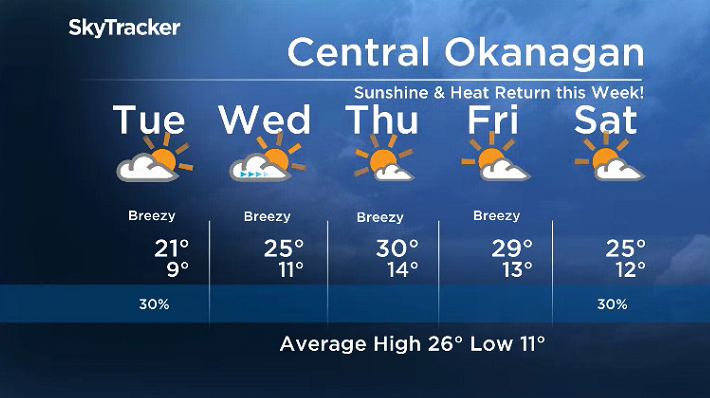
Meantime, after a mix of sun and cloud with breezy winds, mid-20 degree temperatures and a few scattered showers for Canada Day across the rest of the Okanagan, a cooler start to holiday Monday rolled in.
Light rain started off the day with temperatures stuck in low double digits before working their way up through the teens as rain eased into the afternoon.


The risk of rain continues Monday night into Tuesday as the mercury slips back toward single digits overnight.
The Okanagan will stay under the influence of an upper-level low pressure system sitting in Alberta on Tuesday.
As a result, mostly cloudy skies are expected for much of the day with a slight chance of showers.
A few sunny breaks possible at times, which should help warm most of the region into the low 20s by later in the afternoon.

Wednesday will mark a return to blue skies and sunshine, at least in the morning, before some clouds roll in later in the day as temperature spring up into the mid-20s for an afternoon high.
An even bigger warm-up is on the way for Thursday as an upper ridge builds to keep skies sunny, helping boost daytime highs toward the 30s before a slight cool down heading into the weekend.
For the latest weather alerts download the Global News SkyTracker Weather App for iPhone, iPad or Android.
Comments
Want to discuss? Please read our Commenting Policy first.