

A new project spearheaded by researchers at Dalhousie University is hoping to map out the locations of North Atlantic Right Whales — and help the endangered species survive in Canadian waters.

The project, called WhaleMap, comes out of Dalhousie University and the Marine Environmental Observation, Prediction and Response Network’s Whales, Habitat and Listening Experiment — collectively known as the MEOPAR-WHaLE project.
Hansen Johnson, a PHD student at Dalhousie University, is the lead researcher on WhaleMAP.
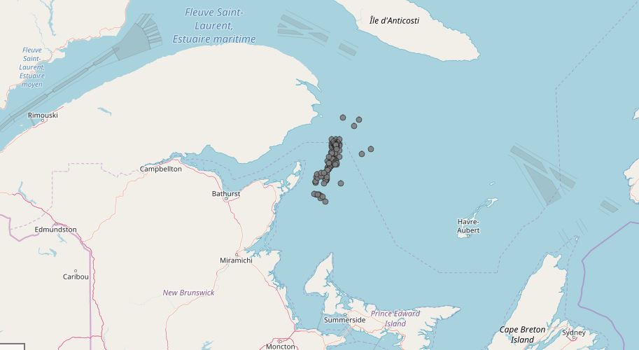
The project combines verified sightings and acoustic detection to provide an up-to-date map of right whale observations over the past 14 days.
It’s not supposed to be used for navigation or fisheries management, but rather for co-ordination of field research efforts. The project has been released as even more attention is drawn to the plight of right whales in Canadian waters.
READ MORE: Canada announces additional fishery closures after more Right Whales spotted
Canada has carried out dynamic closures of fishery zones in the Gulf of St. Lawerence this summer in an attempt to protect the endangered species of whales, 18 of which were killed in Canadian and U.S. waters in 2017.
At least 17 areas in the Gulf are are now closed to the snow crab, toad crab, rock crab, lobster and whelk fisheries.

Get breaking National news
Dominic LeBlanc, Minister of the Department of Fisheries and Oceans (DFO), announced changes to the dates of the snow crab season back in March, in an attempt to protect right whales in the Gulf of St. Lawrence.
The speed limit was also reduced to 10 knots for large ships in the Gulf last year, and will be reinstated between April 28 and Nov. 15.
There are believed to be fewer than 450 North Atlantic right whales remaining.
It’s for that reason that Johnson created WhaleMap.
“This map was designed to communicate the latest right whale observations and survey results to scientific, regulatory and industrial sectors to inform more effective, dynamic planning of research and conservation activities,” Johnson wrote on the project’s website.


-
![]() Aerial survey on endangered right whales to be conducted
Aerial survey on endangered right whales to be conducted -
![]() Nine more fishing areas to close in order to protect endangered right whales
Nine more fishing areas to close in order to protect endangered right whales -
![]() Fisherman voice frustrations with changes implemented to save right whales
Fisherman voice frustrations with changes implemented to save right whales -
![]() New measures introduced to protect right whales
New measures introduced to protect right whales -
![]() Fisheries minister announces changes to snow crab season, speed limits to protect right whales
Fisheries minister announces changes to snow crab season, speed limits to protect right whales -
![]() Canada imposes new measures to protect endangered North Atlantic right whales
Canada imposes new measures to protect endangered North Atlantic right whales


WhaleMap pulls data from some of the largest oceanic institutes and government organizations in North America, including: the DFO, Transport Canada, the National Oceanic and Atmospheric Administration (NOAA), the Canadian Whale Institute, the Ocean Tracking Network and Dalhousie University.
“Their dedication and collaborative spirit give this species the best chance at survival.”
The project even got a shout-out from the the official DFO Twitter account.
Comments
Want to discuss? Please read our Commenting Policy first.