

After a long drawn out spring, it’s great to finally see summer-like temperatures across most of the country.

When Canadians are able to hit the beach, BBQ and plant their garden in May, it almost feels like we’re getting a “bonus summer.”
The question everyone’s asking is, “Will this amazing weather stick around?”
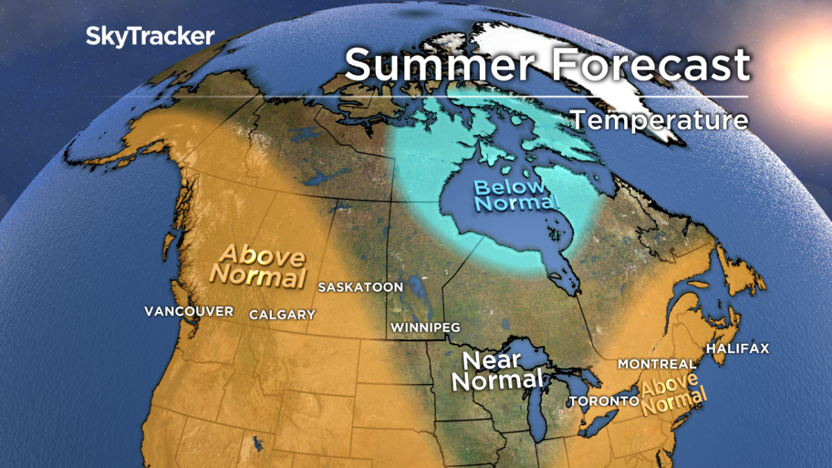
The answer is a complicated one with no strong signals like El Nino or La Nina to guide our seasonal forecast this year. In years like this, we rely heavily on the signs left behind in spring (dry out west, wet and cool around the Great Lakes) and teleconnections (years with similar weather patterns). Overall, we are calling for a typical to warm summer for most of Canada with few exceptions.
BC
The heat came on strong in May, combined with a record late-season mountain snowpack to create ideal conditions for flooding.
A persistent high-pressure ridge near the west coast will lead to another sunny, dry and very warm summer. This also means another active fire season, especially in late July and August.
Prairie Provinces

Get breaking National news
The hot summer weather will also spread east through Alberta and Saskatchewan with near normal temperatures confined to Manitoba.
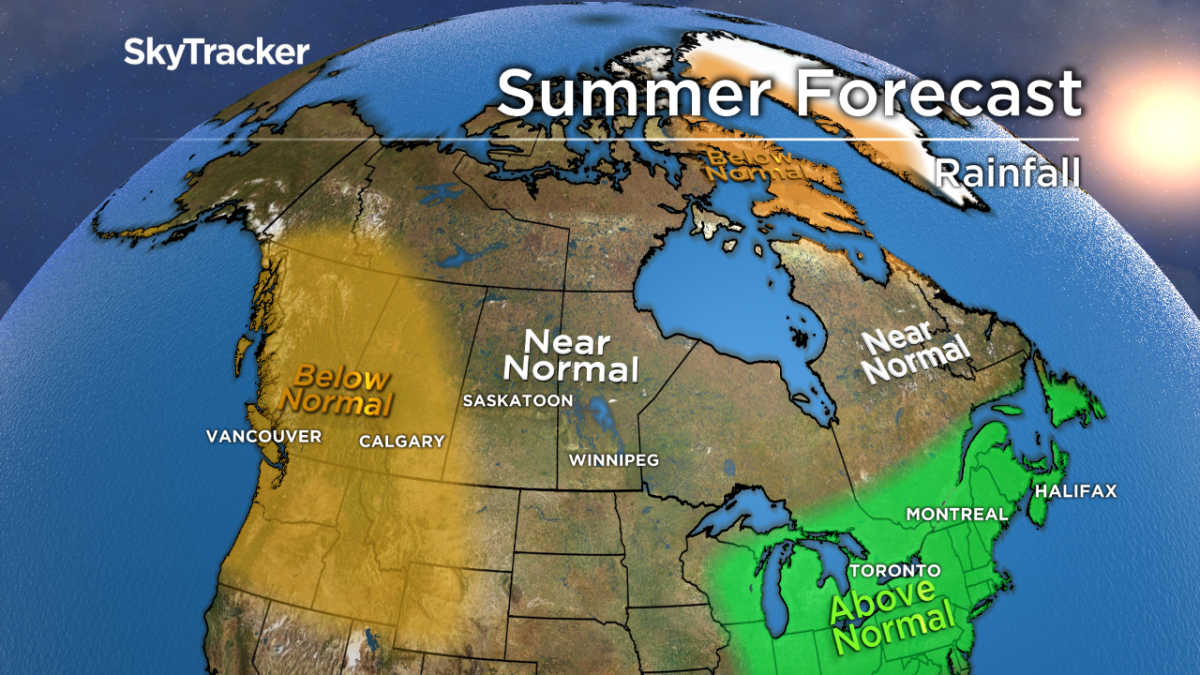
It has been an extremely dry spring across the eastern prairies, with cities like Winnipeg seeing almost no rainfall.
Several troughs will turn the weather more unsettled in June and July leading to normal precipitation, which is great news for farmers.
Ontario and Quebec
The hangover from a chilly spring will last into June across southern Ontario.
The Great Lakes are colder than normal, which will lead to below average temperatures to start summer.
These cold lakes will initially act like a shield, preventing severe thunderstorms, but watch out later this summer as the water warms up.
Temperatures will be near normal across western/northern Ontario under a semi-permanent trough, with more heat in July and August further east from Toronto to Montreal. Much like last year, summer weather will continue well into September and October.


Atlantic Canada
Now that the record flooding has subsided across New Brunswick, much drier weather will remain in place through June across the Maritimes.
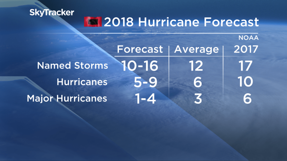
The ocean temperatures in the northwestern Atlantic are running several degrees above normal, which will lead to a warm second half of summer and a much higher-than-normal chance of tropical storms or hurricanes impacting the region.
Above normal precipitation is expected.
Yukon, NWT and Nunavut
Below normal temperatures are forecast around Hudson Bay and Nunavut this summer with near normal precipitation.
For Yukon, the western ridge will extend north, bringing much milder air and an abundance of sunshine, especially in July and August.
- Michael Kovrig reflects on ‘brutally hard’ Chinese detention: ‘You’re totally alone’
- Conservatives set to table non-confidence motion Tuesday. What to expect
- After controversial directive, Quebec now says anglophones have right to English health services
- Something’s fishy: 1 in 5 seafood products are mislabelled, study finds


Comments