

Thick fog reduces visibility as air quality starts to improve.

February 2018 Facts
With the wild start to March, the February facts got buried – but here they are!
It was a frigid month with temperatures trending a whopping 5.6 degrees colder than normal.
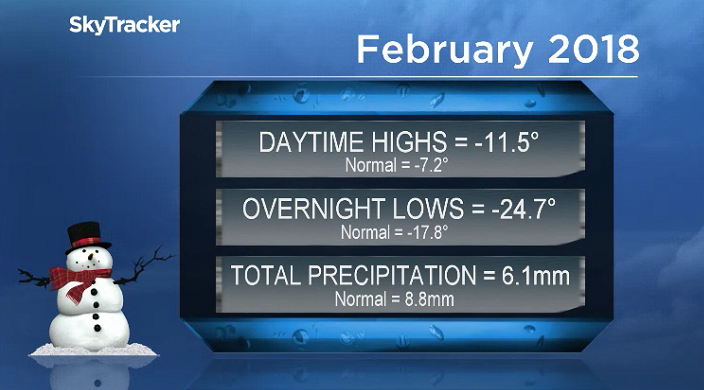
Most of that was on the overnight low side of things, which were almost seven degrees below seasonal – which is unprecedented when averaging out 28 days of data.
The mercury plunged into the -30s an impressive eight days during the month, when normally that only happens three times.
READ MORE: March storm blasts Sask. with heavy snow
The city only saw 69 per cent of our average precipitation throughout the month, with 6.1 millimetres of melted snow reported at the airport throughout February, when normally we see 8.8 millimetres.
Saskatoon Forecast
Tuesday
Visibility was down to 800 metres at times Tuesday as mist and thick freezing fog rolled in, depositing a beautiful layer of rime frost on surfaces that Saskatonians were greeted to in the morning.
-20 is what it felt like with wind chill to start the day as temperatures dipped back to -14 before the mist started to lift, sunshine kicked into full swing and we warmed into minus single digits by noon.
Air quality remained in the moderate health risk range despite the special air quality statement being lifted for the city with the mercury rising up toward the freezing mark for an afternoon high under sunny skies.

Get daily National news
Wednesday
Fog and mist is likely to linger once again into Wednesday morning as wind chills dive back toward the -20s to start the day.
Mostly sunny skies and a breezy east-southeasterly wind will kick in during the day and help clear skies and warm us up likely above the freezing mark for an afternoon high.

- Edmonton’s stormwater system strained after repeated heavy rain
- First Nations chiefs call for inquiry into Ontario wildfire response
- How the Northern Tornadoes Project helps verify twisters as Alberta on track for record year
- Inquiry hears avalanche danger moderate on day of 2021 fatal Banff snow slide


Thursday-Friday
An upper low will push up from the States on Thursday and bring back the clouds and a chance of snow into Friday, particularly in western Saskatchewan, but there is a chance of seeing a few flurries in the city.

Cloudy skies will help moderate morning temperatures, keeping them around -10 to start with afternoon highs flirting with the freezing mark for the rest of the week.
Weekend Outlook
As that system continues to pummel parts of southern Alberta and British Columbia with more snow this weekend, central Saskatchewan will remain on the edge, with clouds sticking around and a chance of flurries.
Daytime highs will pop up toward the freezing mark both days with morning lows approaching minus double digits.

Oliver Ellis took the March 13 Your Saskatchewan photo near Elrose:

Saskatoon weather outlook is your source for Saskatoon’s most accurate forecast and is your one stop shop for all things weather for central and northern Saskatchewan with comprehensive, in depth analysis that you can only find here.
Comments
Want to discuss? Please read our Commenting Policy first.