Raging wildfires continued to rip across southern California Wednesday, forcing nearly 200,000 people to flee their homes and torching more than 20,000 hectares around the Los Angeles area.

The largest and most destructive of the fires, dubbed Thomas Fire, is a massive 220-square kilometre wildfire in Ventura County northwest of Los Angeles. The blaze had nearly reached the Pacific Ocean on Tuesday night after starting about 50 kilometres inland on Monday.
The Thomas Fire continued to rage Wednesday after jumping a U.S. Highway 101, threatening over 12,000 structures.
California Gov. Jerry Brown declared a state of emergency after another fire erupted late Tuesday night.
“This fire is very dangerous and spreading rapidly, but we’ll continue to attack with all we’ve got,” the governor said. “It’s critical residents stay ready and evacuate immediately if told to do so.”
WATCH: Wildfires spreading in southern California

Here’s what you need to know about the infernos engulfing southern California.
Major fires
Creek Fire: As of Wednesday morning, the blaze has torched more than 4,000 hectares in the San Fernando Valley and destroyed at least 30 structures, according to Cal Fire. As of Tuesday night, the Creek Fire was zero per cent contained.
Rye Fire: As of Tuesday night, the Rye Fire was five per cent contained after charring more than 2,000 hectares in Santa Clarita.
Thomas Fire: The fire continues to burn in the foothills about 80 kilometres north of Los Angeles. The blaze is about 220-square kilometres in size and has burned over 26,000 hectares.

Get daily National news
Bel Air brush fire: A brush fire in Los Angeles’ Bel Air neighbourhood erupted Wednesday morning on the steep slopes of Sepulveda Pass, which carries heavily travelled Interstate 405 through the Santa Monica Mountains, where ridge tops are covered with expensive homes.
Santa Ana winds
California’s Santa Ana winds are intensifying the blazes, fanning the flames across the state’s dry foothills.
“We are still in the middle of an aggressive and active firefight on the ground,” said Robert Welsbie, spokesman for the Ventura Fire Department. “If the winds pick up, we will face quite a challenge.”

Santa Ana winds have long contributed to some of the region’s most disastrous wildfires. Air from high pressure areas blows down toward the Pacific Ocean, speeding up, drying out as they squeeze through mountain passes and canyons. In northern California, the same wind effect is known as Diablo winds.
Smoke visible from space
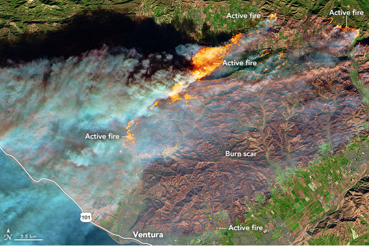
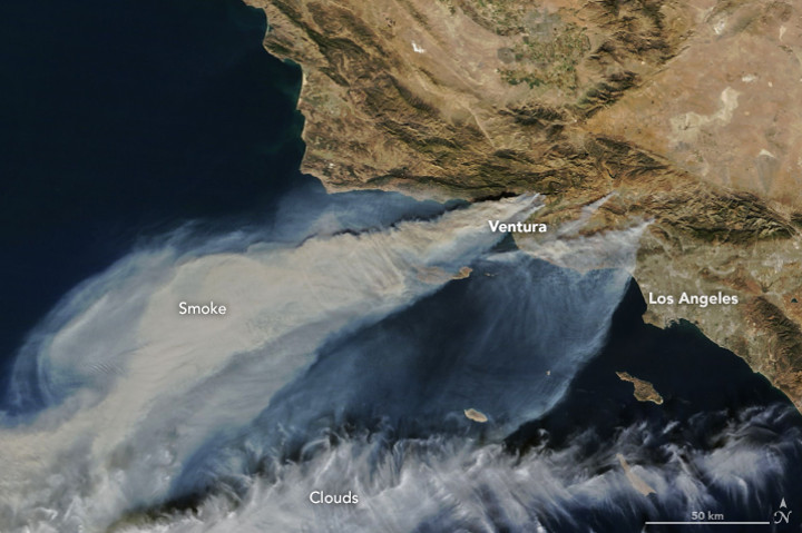
NASA’s Earth Observatory captured satellite images showing the extent of the wildfires where a steady stream of smoke is visible, streaming over the Pacific.
NASA’s Terra satellite captured the “natural-colour” image Tuesday afternoon showing the smoke plumes from the Thomas, Creek and Rye fires.
The space agency noted that “forecasters with the Los Angeles office of the National Weather Service warned that the region is in the midst of its strongest and longest Santa Ana wind event of the year.”
NASA also shared an image captured from the European Space Agency’s Sentinel-2 satellite which shows the “burn scar” from the fires.
Los Angeles looks like “Mordor right now”
Commuters shared videos on social media showing apocalyptic scenes of the fires engulfing the foothills in and around Los Angeles, with some comparing it to Middle Earth, a fictional, hellish setting in J.R.R. Tolkien novels.
–with files from the Associated Press


Comments