

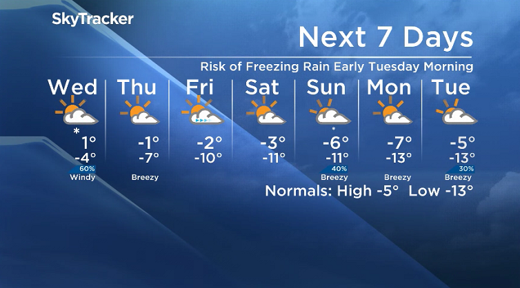
There is a risk of freezing rain as strong winds pick back up.

Saskatoon Forecast
Tuesday
-18 is what it felt like with wind chill this morning on this final Tuesday of November as temperatures slid back to -12 under clear skies.
Winds gusted upwards of 78 km/h Monday night in the city, but eased right back by morning with a warm southerly flow returning during the afternoon under mostly sunny skies.
After making it back into mid-minus single digits by noon, the climb progresses into the afternoon with a daytime high just shy of the freezing mark under partly to mostly sunny skies.

Get daily National news
Tuesday Night
Clouds roll back in Tuesday night as the next system and coupled cold front push through with a risk of freezing rain into the early morning hours as we linger around or just below zero and breezy southerly winds continue.

Wednesday
There is a risk of freezing rain and a rain/snow mix Wednesday morning, which will then likely switch to a chance of snow as the air column over us cools by mid-morning with wind chills around -8.

Winds will pick up in the afternoon behind the system swinging through with sustained speeds as high as 40 km/h and gusts upwards of 60 km/h possible before the ease back in the evening.


After a cloudy start to the day, we should tap into some midday sunny breaks before a few more clouds swing through during the afternoon as we hover around and just below the freezing mark before falling back into mid-minus single digits in the evening.

Thursday-Friday
An upper ridge will linger for the final day of November and help hold us around or just below the freezing mark on Thursday under a mix of sun and cloud.

December kicks off with a few more clouds on Friday before some clearing later on as we climb up to an afternoon high a few degrees shy of positive temperature territory.
Weekend Outlook
The first weekend of December will mark a transition back down toward seasonal conditions with daytime highs back in mid-minus single digits and lows into minus double digits under a mix of sun and cloud on Saturday with more clouds and a chance of flurries as a cold front swings through on Sunday.
Dre Erwin took this Your Saskatchewan photo for Nov. 28 in Pinehouse:

Saskatoon weather outlook is your source for Saskatoon’s most accurate forecast and is your one stop shop for all things weather for central and northern Saskatchewan with comprehensive, in-depth analysis that you can only find here.
Comments
Want to discuss? Please read our Commenting Policy first.