

Hurricane Irma may have left a trail of destruction in the Caribbean, but islands that were ravaged by the “once-in-a-generation” event are now bracing themselves for another system that could hit them with storm-force winds on Friday.

Hurricane Jose formed on Wednesday, and it’s on track to hit the Leeward Islands, an arc of islands that includes Antigua and Barbuda, Saint Martin, the U.S. Virgin Islands and the British Virgin Islands, all areas that Irma hit hard, according to the U.S. National Hurricane Centre (NHC).
Coverage of Hurricane Irma on Globalnews.ca:

-
![]() Hurricane Irma causes havoc in Caribbean
Hurricane Irma causes havoc in Caribbean -
![]() People fleeing Hurricane Irma cause traffic jam on highway out Florida
People fleeing Hurricane Irma cause traffic jam on highway out Florida -
![]() Hurricane Irma lashes Puerto Rico
Hurricane Irma lashes Puerto Rico -
![]() Hurricane Irma hitting British Virgin Islands, Puerto Rico
Hurricane Irma hitting British Virgin Islands, Puerto Rico -
![]() Hurricane Irma lashes Puerto Rico with heavy rain and winds
Hurricane Irma lashes Puerto Rico with heavy rain and winds -
![]() Predicting where Hurricane Irma will hit when it reaches the U.S.
Predicting where Hurricane Irma will hit when it reaches the U.S.


Four people were reportedly killed on four different islands amid the storm. As many as 90 per cent of homes on Barbuda were destroyed, and damage there has been estimated at $150 million, said Gaston Browne, Antigua and Barbuda’s prime minister.
Jose is also expected to hit Puerto Rico, where at least half of the island’s businesses and homes reportedly lost power as Irma blew by.

Get breaking National news
WATCH: Barbuda devastated by Hurricane Irma

Jose is expected to be less intense — winds are expected to hit the islands at up to 177 kilometres per hour, while Irma’s were up to 300 kilometres per hour — but it could intensify in the next 48 hours, said an NHC bulletin on Wednesday night.
And it could hit the U.S. mainland on Saturday or Sunday.
This map shows Hurricane Jose’s probable path:


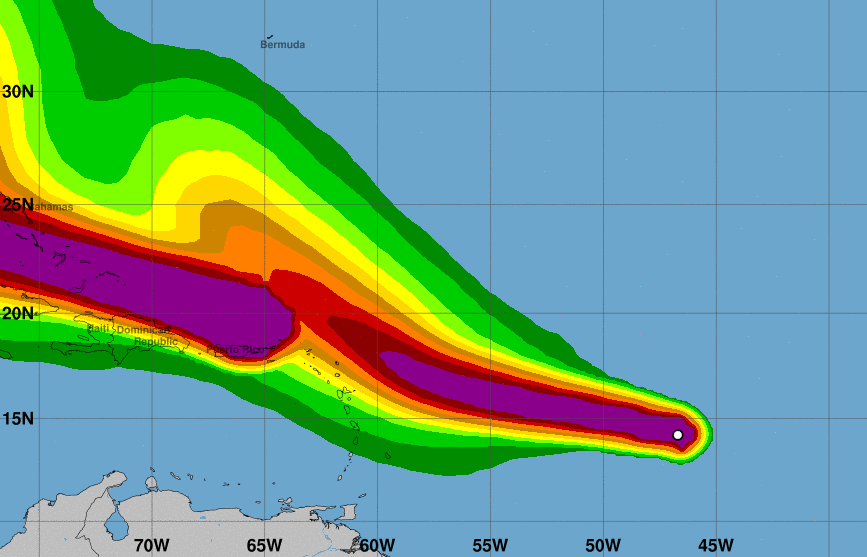
This one shows Jose’s windspeed potential — the darker the band, the more intense the wind:
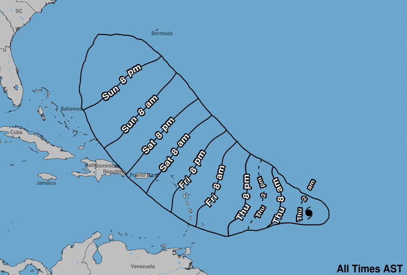
And this one shows the times at which Jose’s storm-force winds are expected to hit:
As for Irma, the storm was moving west-northwestward to the northeast of the Dominican Republic late Wednesday night.
Hurricane warnings were issued for various areas including Puerto Rico, the Dominican Republic from Cabo Engano to its northern border with Haiti, Haiti from the border up to Le Mole St. Nicholas, the southeastern Bahamas, Turks and Caicos and the Central Bahamas.
- With files from Kevin Nielsen and Reuters
Comments
Want to discuss? Please read our Commenting Policy first.