

UPDATE: All watches and warning mentioned in this story have ended

Severe Thunderstorm Watch
Environment Canada has issued a severe thunderstorm watch was for the Saskatoon, Prince Albert, Martensville, Warman, the Battlefords, Kindersley, Rosetown and Meadow Lake areas on Friday for conditions favourable for the development of severe thunderstorms capable of producing strong wind gusts, large hail and heavy rain.
A cold front triggered the thunderstorms during the afternoon as it sliced into an unstable airmass situated over west-central Saskatchewan.
Heat Warning

Get breaking National news
Environment Canada has issued a heat warning for the Melfort, Tisdale, Nipawin, Carrow River, Hudson Bay and Porcupine Plain areas.
Daytime high temperatures Thursday peaked near 29 at Hudson Bay, 33 at Melfort and 32 at Nipawin and only fell to the mid- to high-teens during the night.
The forecast temperature Friday is 29, which satisfies the new heat warning threshold for central and northern Saskatchewan.
READ MORE: Sun safety: reducing your risk of health issues from heat stroke to melanoma
By Saturday morning a cold front will have moved through the region bringing cooler temperatures.
Heat warnings are issued when very high temperature conditions are expected to pose an elevated risk of heat illnesses, such as heat stroke or heat exhaustion.
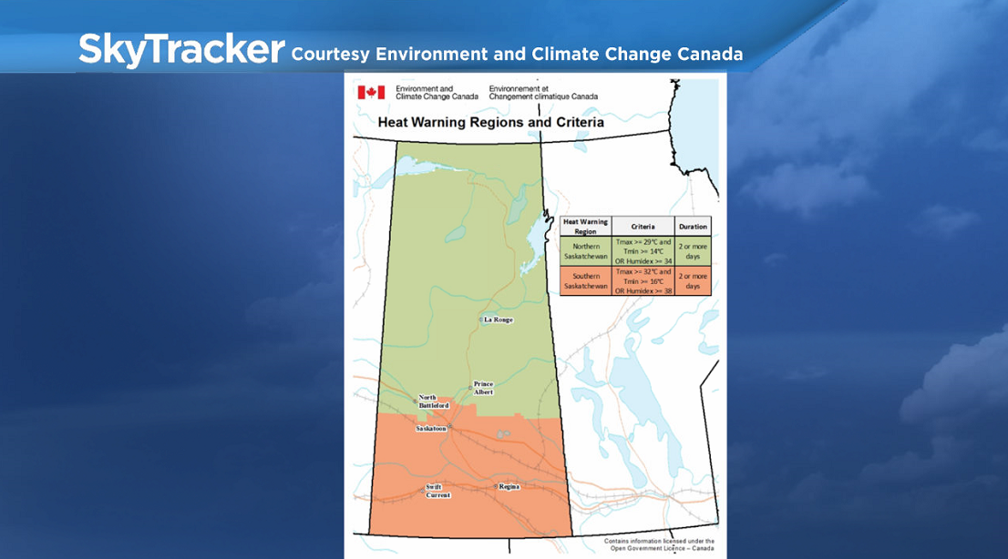
Environment Canada has updated their heat warning criteria for Saskatchewan.
They are now issued in southern Saskatchewan, including the Saskatoon area, when 2 consecutive days of daytime maximum temperatures are expected to reach 32 C or more and nighttime minimum temperatures are expected to fall to 16 C or higher, or if humidex values reach 38 degrees or higher.
In northern Saskatchewan, they are issued when two consecutive days of daytime maximum temperatures are expected to reach 29 C or more and nighttime minimum temperatures are expected to fall to 14 C or higher, or if humidex values reach 34 degrees or higher.


Officials have the following advice for people under a heat wave:
- consider rescheduling outdoor activities to cooler hours of the day;
- take frequent breaks from the heat, spending time outdoors at your house or at cooled public buildings (including malls or indoor pools);
- drink plenty of water and other non-alcoholic, non-caffeinated beverages to stay hydrated; and
- do not leave any person or pet inside a closed vehicle, for any length of time.
For the latest weather alerts download the Global News Skytracker weather app for iPhone, iPad or Android.
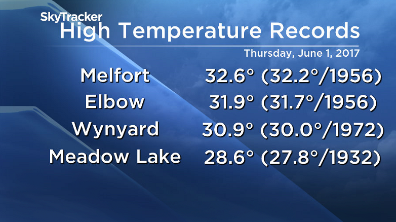
Historic Heat Hits Saskatchewan Thursday
A total of eleven high temperature records were broken on Thursday as a hot, dry air mass shifted into the province.
They included Prince Albert, Regina, Meadow Lake and Melfort.
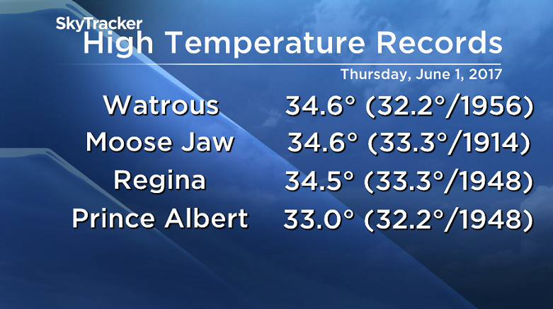
Saskatoon was just shy of a record, reaching 33.8 degrees, 0.1 off of the record of 33.9 degrees set in 1956.
Watrous reached 34.6 degrees, which was not only a record high, but also the hottest place in all of Canada on Thursday.
Spring 2017
Meteorological spring, which includes the months of March, April and May, has just wrapped up and looking back at the numbers, it was slightly warmer and wetter than normal.
The season saw temperatures an average of 0.16 degrees warmer than average, most of which was on the daytime high side of things, which trended around 10 degrees, when normally they are around 9.7.
This is a significant amount, given that we’re averaging over 90 days of data.
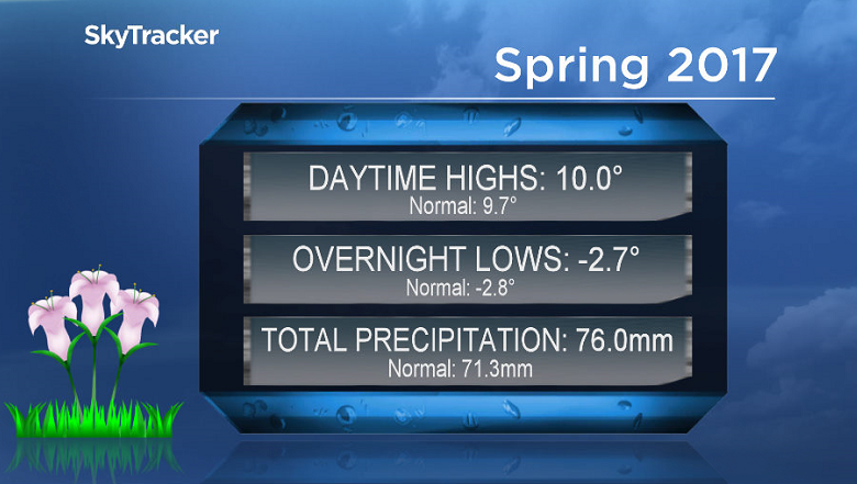
On the precipitation front, the Saskatoon airport reported 76 millimetres throughout the three month period, which is 107% of our normal amount of 71.3 millimetres.
READ MORE: May 2017 was warmer and wetter than normal in Saskatoon
June 1 marked the start of meteorological summer, which is expected to be warmer than normal for central Saskatchewan with around average precipitation.
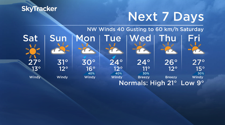
Saskatoon Forecast
Today
After a day of 30 degree heat, we had a mild start to the day around 17 degrees under mostly cloudy skies thanks to a trough swinging through.
Moderate southerly winds around 30 km/h kicked up late morning as we warmed into the mid 20s by noon.
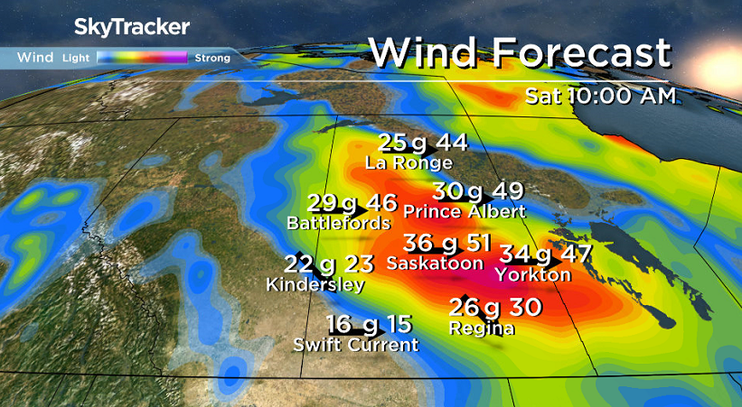
This afternoon there is a chance of a severe thunderstorm rolling through as we warm up a few more degrees to around 27 for a daytime high before cooling off behind a cold front with westerly wind gusts up to 50 to 60 km/h.
Tonight
There’s a chance of some lingering showers and risk of a thunderstorm early this evening before clouds clear out overnight as we cool back into the low teens.
Saturday
It’ll be another windy Saturday for Saskatoon with a cool northwesterly wind picking up to speeds of 40 km/h with gusts upwards of 60 km/h.
Sunny skies will dominate the day though with an afternoon high expected to top out around 27 degrees.
Sunday
An upper ridge builds back in on Sunday, warming us back up into the low 30s for a daytime high as a breezy southeasterly wind moves back in.
The day will start off with some sunshine, however some clouds are likely to build in during the afternoon as a pulse of moisture pushes in.
Work Week Outlook
The 30 degree heat may hang on for one more day on Monday with a system south of the area destabilizing the atmosphere, bringing in clouds and a chance of thundershowers during the day.
There is a chance of some lingering rain on Tuesday as we slip into some slightly cooler air before we get into some more sunshine later in the week with daytime highs settling into the mid 20s.
This Your Saskatchewan photo was taken by Garfield MacGillivray at Quill Lake:

Saskatoon weather outlook is your source for Saskatoon’s most accurate forecast and is your one stop shop for all things weather for central and northern Saskatchewan with comprehensive, in depth analysis that you can only find here.
Comments
Want to discuss? Please read our Commenting Policy first.