

Another stunning, 20-degree day is on the way before a big cool down ahead!

Snowfall Warning
A snowfall warning has been issued for the Cumberland House, Pelican Narrows and Southend areas for 10 to 15 centimetres of snow.
A low pressure system over southern Alberta will track across Saskatchewan on Saturday and spread wet snow into portions of northeastern Saskatchewan beginning Friday night.

10 cm of heavy wet snow is possible by late Saturday afternoon before conditions improve Saturday evening.
Environment Canada says rapidly accumulating snow could make travel difficult over some locations and visibility may be suddenly reduced at times.
Record Breaking Heat
Three high temperature records were broken on Thursday in parts of central Saskatchewan as the mercury soared into the low 20s.
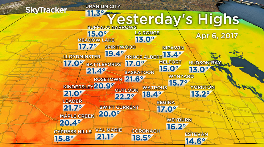
Saskatoon broke an 87-year-old high temperature record Thursday afternoon from 1930 of 20.6 degrees as we rose up above that at of 4 p.m. CT.
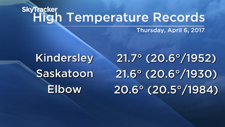
Leader was the hot spot in the province at 22.6, although this fell just shy of the record of 22.8 set in 1952.
Saskatoon Forecast
Today
Another incredibly warm day today with temperatures starting out at 6 degrees under partly to mostly cloudy skies to start the day with some more sunshine moving in midday.
We quickly warmed up into double digits by 9 a.m. this morning with southerly winds picking up to 20 to 30 km/h, which helped warm us up into the high teens by noon.
This afternoon we’re expecting some more clouds to move in as we rise up to a daytime high in the low 20s for the second day in a row, but just shy of our record high of 23.8 degrees from 2005.
Tonight
Clouds will continue to pour in tonight as a low pressure system develops in Alberta, bringing in a chance of showers overnight before we may get into some clearing before morning as we cool to +5.
Strong southwesterly winds will kick in overnight at sustained speeds of 25 to 35 km/h and gusts into the 50 to 60 km/h range at times.

Saturday
That low will then track in over the region on Saturday with strong southwesterly winds continuing in the morning with gusts upwards of 60 km/h.
It looks like we’ll see some sunshine in the morning with clouds building in by midday with a good chance of rain during the afternoon after we reach a high likely just into the low teens.


Behind the system strong northerly winds will kick in tomorrow evening before easing overnight with gusts upwards of 50 km/h, quickly cooling us down with a chance of a few wet flurries mixing in before precipitation eases overnight.

Sunday
The weekend will end on a cooler and sunnier note on Sunday behind the system with clearing conditions during the day.
Temperatures will start out below freezing but will warm into mid-single digits by afternoon for a daytime high.

Work Week Outlook
Monday morning will be chilly with wind chill values in minus double digits to start as temperatures fall back to -5 or so before warming up into high positive single digits as clouds return.
Clouds are expected to dominate the majority of next week with daytime highs returning into low double digits and a chance of showers at times.

This Your Saskatchewan photo was taken by Colin Campbell in Saskatoon:

Saskatoon weather outlook is your source for Saskatoon’s most accurate forecast and is your one stop shop for all things weather for central and northern Saskatchewan with comprehensive, in-depth analysis that you can only find here.
Comments