

It’s an awesome start to April if you like warm weather and there’s heat, rain and a chance of thunderstorms ahead.

March 2017 Look Back
Saskatoon saw an almost “normal” March 2017 with average temperatures trending 0.2 degrees warmer than normal overall.
It was a slightly drier than normal month with 11.3 millimetres of precipitation reported at the airport, which is 72 per cent of our March average of 15.6 millimetres.


It was a snowier than normal winter in the city with 100 to 120 centimetres of snow falling between October 2016 and the end of March 2017.
On average, we normally see 91 centimetres of snow in Saskatoon.
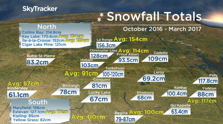
Up to 214.8 centimetres of snow fell this winter in northern Saskatchewan with northeastern portions of the province seeing the heaviest snowfall of all areas.
We may not be done with the snow yet – on average, Saskatoon sees eight centimetres of snow in April and two centimetres in May.

Saskatoon Forecast
Today
-8 is what it felt like with the wind chill this morning as temperatures fell back to -4 to start the day in Saskatoon.
We warmed up quickly though with a glorious morning filled with mostly sunny skies, which helped us warm up into high single digits by late morning.
It’s an unstable day, which means clouds will bubble up through the day with a chance of a shower or our first thunderstorm of the year later on and an afternoon high in low double digits.
Tonight
That chance of showers and thunderstorms lingers into the evening before we see clouds start to clear out overnight as temperatures fall back a few degrees below freezing overnight.
Tuesday
-8 is around what it’ll feel like tomorrow morning with the wind chill when you head out the door tomorrow morning with some sunshine to start the day.
A pulse of moisture pushing through will build in the clouds during the day and bring a chance of showers and even the potential for a stray thunderstorm in the afternoon and evening as we warm to a daytime high just into double digits.


Wednesday-Friday
An upper ridge of high pressure will build in the heat big time for the rest of the work week, pushing daytime highs from low double digits on Wednesday into the mid-to-high teens Thursday and Friday.
Clouds will be in and out both Wednesday and Thursday before they move in to stay on Friday with a good chance of showers as a low pressure system presses in.

Work Week Outlook
It’s still a ways away, but at this point the weekend is shaping up to be overcast with a good chance of rain, particularly on Saturday as a few low pressure systems slide by south of the region.
Cooler air slides daytime highs back from double digits into single digits from Saturday through Sunday with breezy conditions expected throughout.


Saskatoon weather outlook is your source for Saskatoon’s most accurate forecast and is your one stop shop for all things weather for central and northern Saskatchewan with comprehensive, in depth analysis that you can only find here.
Comments