

More snow today before we head into extreme -40 wind chills.

Snowfall Warning
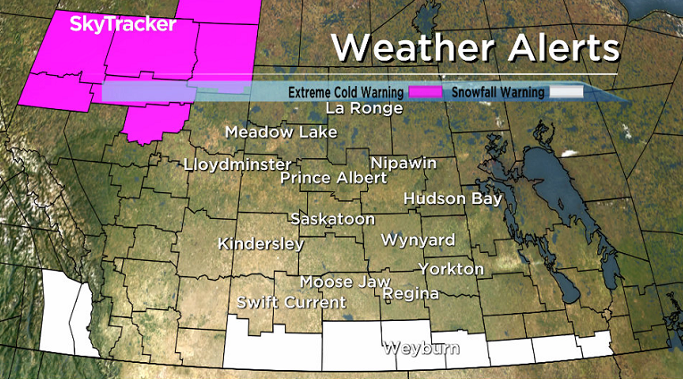
A series of disturbances crossing the Rockies will continue to bring snow into southern Saskatchewan today.
20 to 30 centimetres of snow fell in southwest Saskatchewan over the weekend with a further 5 to 10 centimetres expected today along and south of the Trans-Canada highway.
The snow will begin tapering off from west to east tonight as a ridge of high pressure builds into the area.
Parts of southwestern Alberta saw over a metre of snow over the weekend with Waterton National Park receiving 120 centimetres from Friday through Monday.
READ MORE: Heavy snow hits southern Alberta
For the latest weather alerts download the Global News Skytracker weather app for iPhone, iPad or Android.
Saskatoon Forecast
Today
Saskatoon saw temperatures dip back to -22 overnight with wind chills making it feel like the -30s all morning.
Mostly cloudy skies were the main feature of the first half of the day with the northern edge of the snowy system in the south sliding into the city just before noon.
Light snow will continue for the rest of the day with the mercury attempting to nudge up into the minus teens for a daytime high.
Tonight
Light snow will continue tonight as temperatures fall back into the mid -20s.
Tuesday
-34 is what it’ll feel like with wind chill tomorrow morning when you head out the door under cloudy skies with a chance of light snow continuing into the morning.
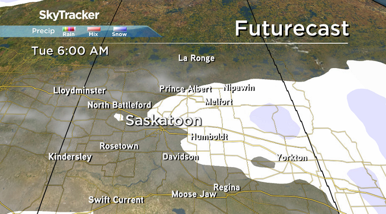
Clouds will linger through the day as the chance of snow diminishes before skies start to clear in the afternoon with temperatures rising up to around -20 and wind chills sitting in the -30s all day.
Wednesday-Friday
An arctic high moves in on Wednesday, dropping thermometers back to around -28 in the morning with extreme wind chill values into the -40s likely under clear skies.


Sunshine should dominate much of the day with a chance of a few clouds move through in the first half of the day or so as temperatures rise up just into the minus teens for an afternoon high.

After another sunny and clear start on Thursday, clouds and snow move back in during the afternoon a low pressure system slides into southern Alberta, which will also help warm us up to a high in the mid-minus teens.
Right now that system looks like it’ll slide through on Friday with snow, cloud cover and temperatures potentially topping out in minus single digits for an afternoon high.
Weekend Outlook
At this point Saturday looks to start off with some cloud cover before some clearing later on with a mix of sun and cloud on Sunday after a slight chance of flurries early on.
Daytime highs both days look like they’ll be in mid-minus single digits as an upper ridge of high pressure helps warm us back up into next week.
Kathy Laliberte took this Your Saskatchewan photo of an ice heave in Île-à-la-Crosse:

Saskatoon weather outlook is your source for Saskatoon’s most accurate forecast and is your one stop shop for all things weather for central and northern Saskatchewan with comprehensive, in depth analysis that you can only find here.
- Toronto’s construction season traffic is ‘unacceptable.’ Is there a better way?
- More foreign interference action coming after inquiry report, India arrests: LeBlanc
- Why MP questions put the Bank of Canada governor in a political minefield
- Amid bird flu spread, Canada boosts surveillance and testing at border
Comments