

-50 wind chills this morning, an extreme cold warning remains in effect and a big warm-up is on the way!

Extreme Cold Warning
Environment Canada has continued an extreme cold warning in Saskatoon, central and parts of northern and southern Saskatchewan with a prolonged period of very cold wind chills expected.
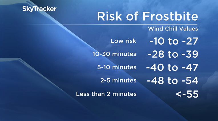
Extreme wind chills of -40 to -45 are expected across the region today through tonight into Friday morning.
Frostbite on exposed skin is possible within 10 minutes in these conditions.
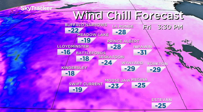
-53 is what it felt like in Key Lake this morning with the wind chill and -51 in Meadow Lake.
Saskatoon’s lowest wind chill reading was -46 at 10 a.m. CT this morning.
For the latest weather alerts download the Global News Skytracker weather app for iPhone, iPad or Android.
Saskatoon Forecast
Today
After blowing snow last night and treacherous road conditions across the region behind the low pressure system that brought the snow we slid back into the deep freeze.
READ MORE: Whiteout conditions prompt RCMP to advise against travel near Saskatoon
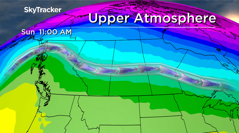
Skies cleared overnight as an arctic high pressure system moves back in and the polar vortex pushing through in the upper atmosphere, causing temperatures to fall quickly.
Saskatoon dropped to a morning low of -34, which felt like -46 with wind chill as extreme cold warnings continued into the day.
By noon, the mercury had risen up to -30 with a wind chill of -40 under mostly sunny skies, which are expected to continue for the rest of the day as we rise up to a high just a few degrees into the -20s.
Tonight
Mostly clear skies tonight will allow us to drop back into the -30s overnight with wind chills just into the -40s, however a push of warmer, Pacific air will take hold and allow temperatures to rise up to the mid -20s by morning.
Friday
-35 is around what it’ll feel like with wind chill when you head out the door Friday morning under mostly sunny skies.


We continue to warm through the day in the sunshine with a southerly breeze, which will allow the mercury to rise up into the mid-minus teens for an afternoon high.
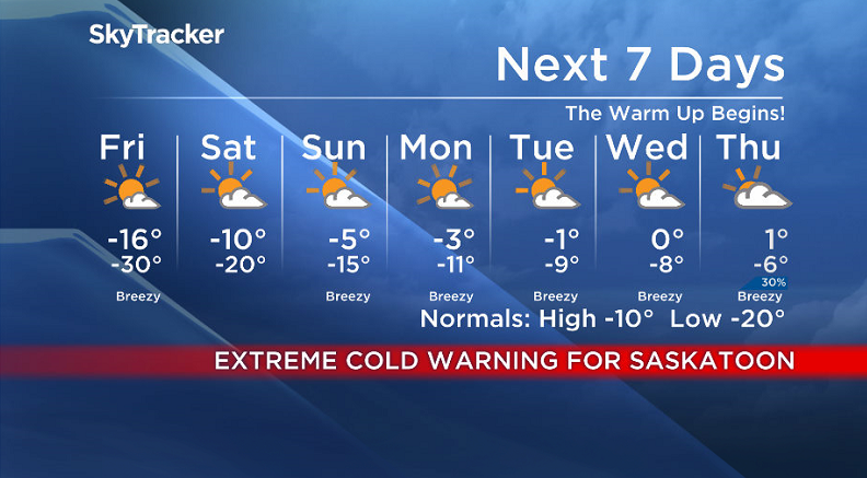
Weekend
An upper ridge of high pressure continues to build in the heat this weekend under partly to mostly sunny skies throughout.
We’re expecting to climb to a daytime high around -10 on Saturday before bumping up into mid-minus single digits Sunday afternoon!
Work Week Outlook
We continue to warm-up right through the work week as we remain in the warm sector of systems sliding by to the north of us.
That will help bump our daytime highs up toward and possibly even above the freezing mark under partly to mostly sunny skies.
This Your Saskatchewan photo was taken by Bill Allen in Ralph:

READ MORE: Get a 2017 Your Saskatchewan calendar today
Saskatoon weather outlook is your source for Saskatoon’s most accurate forecast and is your one stop shop for all things weather for central and northern Saskatchewan with comprehensive, in depth analysis that you can only find here.
Comments