

-33 wind chills today won’t let up for your weekend forecast as even colder arctic air sinks in with the arrival of the polar vortex.

Saskatoon Forecast
Today
No relief from the cold today as we woke up to -25, but as you walked out the door you faced -32 with the wind chill in Saskatoon.
It was a northwest wind that started off our day, which swung around to north by noon, but that didn’t make a dent in that wind chill factor, allowing for a noon hour wind chill of -33.
There was no snow to start off our day and we did have some sunny breaks in the morning, and some clouds are expected to build their way back into Saskatoon around the dinner hour – though it won’t be as noticeable seeing as the sun will be down by 4:55 p.m.
Mainly sunny skies will stick around for the rest of the day with our daytime high expected to be around -22, but feeling in the -30s all afternoon with the wind chill.
Tonight
Some clouds building, and temperatures will fall into the -30s overnight, with an easterly wind of 10 km/h.
Saturday
-38 to -39 is what it’ll feel like tomorrow morning with wind chill when you head out, which means you need to be aware of exposed skin and the frostbite factor that comes along with these cooler temperatures.
We’ll start off the day with a mix of sun and cloud, with more clouds building into the afternoon. We can expect winds up to 15 km/h and that wind chill of -39 as the polar vortex settles in for the weekend.
Weekend Outlook
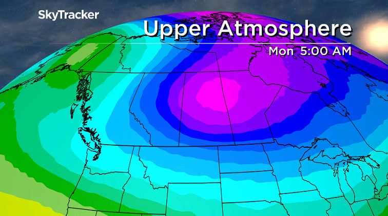
Some of the coldest air on earth associated with the polar vortex, a cool pool of air in the atmosphere that typically hovers over the North Pole, pushes in this weekend and into the start of your work week as well.


There is a 60 per cent chance of flurries starting in the evening hours of Saturday with a low of – 29. This pushes out for Sunday morning, clearing for mostly sunny skies with a daytime high of -24. Don’t let Mr. Sun fool you though, with those wind chills values you’ll still need to be prepared to cover any exposed skin when you are outside. With wind chill values close to the -40s on Sunday, that is the criteria required for an extreme cold warning to be issued by Environment Canada.
For the latest weather alerts download the Global News Skytracker weather app for iPhone, iPad or Android.
This Your Saskatchewan photo was taken in Scott by Shelly Gerein:

Saskatoon weather outlook is your one stop shop for all things weather for Saskatoon, central and northern Saskatchewan with a comprehensive look at your local forecast that you can only find here.
- Toronto Pearson gold heist: Ontario man arrested at airport after arriving from India
- Capital gains changes could have ‘irreversible’ effects, business groups warn
- Renters so far more ‘vulnerable’ than homeowners amid higher interest rates. Why?
- After tornado outbreaks in the U.S., could Canada see similar storms?
Comments