
Two tornadoes touched down east of Saskatoon Sunday, one on the northern edge of a Saskatchewan town.

Father’s Day funnel clouds and tornadoes
It was an active Father’s Day across Saskatchewan.
Two tornadoes touched down east of Saskatoon over the noon hour on Sunday in the Naicam area.
READ MORE: Multiple tornadoes touch down in Saskatchewan on Father’s Day
The first funnel popped out of the cloud deck just before noon, touching down around noon :approximately 10 kilometres west of Naicam and lasted for about five minutes.
The second tornado touched down about 12 minutes later on the northern edge of the townsite, lasting about three minutes.
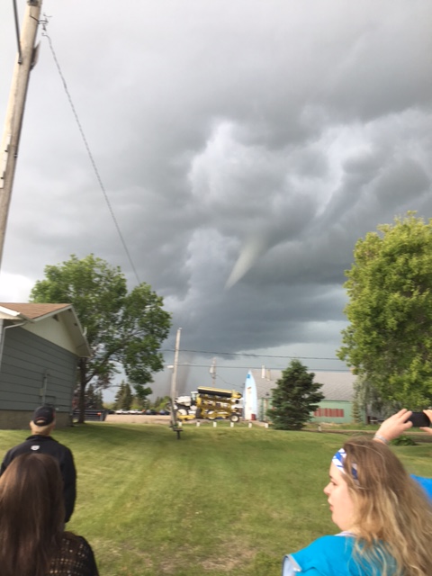
There were no reports of damage from either tornado, however numerous other funnel clouds were reported across the region.
The first funnel cloud was reported at 11:25 a.m., two kilometres north of Bruno followed by numerous other reports between Humboldt, Saint Brieux and Naicam over the next couple of hours.

Get breaking National news
The last report was reported eight kilometres east of Saint Brieux at 2:10 p.m.
Saskatoon Forecast
Today
After a wild weekend of weather, today has been pretty calm.
We started the day out in mid-single digits, sitting around 6 degrees under clear skies before eventually warming up in the sunshine to the 20s early this afternoon.
A northwesterly flow aloft will keep us cooler today, but that will change in the days ahead.
Tonight
Skies will remain mostly clear tonight with temperatures dropping back just into single digits.
Tuesday
Tomorrow will start off sunny before clouds build in through the early afternoon with a chance of showers in the evening as an area of low pressure slides by to the south of us.
We should hit an afternoon high in the mid-20s tomorrow afternoon with south-southeasterly winds around 20 km/h.


Wednesday-Friday
There is a chance of showers late in the day on Wednesday under mostly cloudy skies before we get a bit of a break with some more sunny breaks on Thursday.
Friday looks to see a chance of showers once again with a low pressure system moving into northern Saskatchewan keeping conditions unsettled.
Temperatures are expected to top out in the mid-20s both Wednesday and Friday with a high possibly pushing into the high 20s on Thursday.
Weekend Outlook
The low centred in the north will sweep through over the weekend, dropping temperatures, keeping us cool, windy and unsettled with a chance of rain and even the possibility of some thunderstorms once again.
Daytime highs will struggle to crack into the low 20s both days.
This Your Saskatchewan photo was taken in Saskatoon by Mat Williams:

Saskatoon weather outlook is your one stop shop for all things weather for Saskatoon, central and northern Saskatchewan with a comprehensive, detailed look at your local forecast that you can only find here.
Comments
Want to discuss? Please read our Commenting Policy first.