
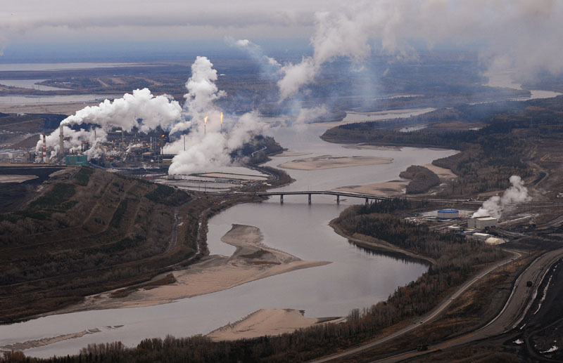
Oil sands production depends on water — a lot of it.

Bitumen is either extracted from the soil with steam or with heated water. It takes about two and a half barrels of water to produce a barrel of oil.
Much of that water comes from the Athabasca River, which is filled by rainfall and snowpack high in the Rockies. At the moment, oil sands production uses a small percentage of the Athabasca’s flow.
But three interconnected threats may make the river’s flow far smaller in the future than it is today:
Drought
The Athabasca River’s flow has been measured since the early 1950s and water allocation decisions are based on that data, says University of Regina geography professor David Sauchyn. But recent research shows that recent decades have been a wet period. The region’s deeper history shows long, severe droughts.
Sauchyn studied rings on trees in the Athabasca’s headwaters, in Jasper National Park, which were up to 900 years old. They told a story of regular droughts — in the 1930s, the 1860s, and a long one through the end of the 18th and early 19th centuries.
Over time, the region has seen cyclical droughts, and it’s a question of when, not if, the next one will arrive.
The drought that started in 1790 lasted for 17 years, the tree rings show. Hudson’s Bay Company records from the period complain that canoes were damaged in low water and that trade routes were disrupted. The region also saw large forest fires.
- ‘Shock and disbelief’ after Manitoba school trustee’s Indigenous comments
- Invasive strep: ‘Don’t wait’ to seek care, N.S. woman warns on long road to recovery
- Norad looking to NATO to help detect threats over the Arctic, chief says
- ‘Super lice’ are becoming more resistant to chemical shampoos. What to use instead
One drought in the Middle Ages lasted 56 years, and another lasted for nearly a century.
READ MORE: Oilsands water restrictions a climate change ‘preview:’ study
“In a normal year, they’re only taking a few per cent of the river flow,” Sauchyn says. “It’s a fairly large river, and they’re taking a relatively small amount in an average year. If you take a dry year, or a very dry year, that proportion goes way up.”
The region’s droughts will come again, Sauchyn says.
“The oil sands industry has only existed since 1967, and since ’67 there haven’t been consecutive dry years. But there have been consecutive dry years for decades.”
Rising temperatures
A new danger, though, comes as we combine cyclical drought with global warming. A long drought, like the one that started in 1790, would have much more serious effects.
“The water was below average for 17 consecutive years. If that was to reoccur in the future, it’s reoccurring in a warmer climate. It’s much warmer now than it was in the 1790s – much, much warmer. So it’s a double-whammy.”
“It’s amplifying the problem, because you’re without water, but you’re without water in a much warmer climate where there’s a much higher demand for water.”
READ MORE: 7 major changes the Prairies will see as the climate warms
The combination of the two factors could be dangerous, says Shawn Marshall, a glaciologist at the University of Calgary: “The fear, I guess, and it’s a legitimate one, is what that’s going to look like.”
In May, climate researchers at the University of Winnipeg’s Prairie Climate Centre predicted that the region will see a steadily increasing number of days with temperatures over 30 C.
Fort McMurray, which now has about four over-30 days a year, will see about 20 by mid-century, they say. That’s similar to the climate of modern-day Estevan, Sask., which is almost on the U.S. border.
Shrinking snowpack and glaciers
Part of the Athabasca River’s flow comes from meltwater hundreds of kilometres away, in the Rockies. As the snowpack and glaciers shrink, however, that source can’t be relied on.
As the glaciers shrink, however, water flows could actually increase — temporarily.
“A few years ago, they thought that the upper reaches of the Athabasca were actually getting increased flows because of the huge amount of glacier melt coming off,” Marshall explains. “But after you’re getting your peak water it starts to decline, because you don’t have as much glacier left.”
“It’s essentially fossil water that you start off with, from the 1700s, 1800s, and we’re burning through that, and we’ve enjoyed that kind of extra water, but then you’ve spent it and then it’s gone, and then you lose your fossil water completely. “
By the time it reaches Fort McMurray, meltwater forms a fairly small part of the river’s flow, Marshall says, though in a drought it would form a proportionately larger one.
If it keeps flowing, that is.
READ MORE: Oilsands water plan short-sighted: Athabasca River study
“As long as the snow keeps falling, in the mountains, there will still be water in those rivers, but there will be less flow, especially in the late summer. You lose that sort of regulator — the glaciers sort of act like a reservoir to store some of that water, but in this case it stores it for centuries, in the case of the Columbia icefield.”
“I think the industry feels like they have the water supplies they need from there, but a lot of people think that might not be true, because we haven’t really seen what it looks like when it gets hot and dry in a warmer climate,” Marshall reflects. “And we’ve lost that glacier input.”
VIDEO: Water use restrictions have been placed on dozens of energy companies due to low flows on the Athabasca River. As Margeaux Morin explains, some experts think that this summer is just a preview of what we can expect in the coming decades.
Comments