
TORONTO – As Manitoba prepares for another deluge, we take a look at the worst floods in Canadian history. And – you guessed it – Manitoba is the leader.

1. Red River Flood 1997 (“The Flood of the Century”)
On Feb. 27, 1997, the city of Winnipeg prepared for potential spring flooding, a common occurrence for that part of Canada. But between April 5 and 8, the province was hit by a blizzard that dropped about 50 cm of snow across the Red River Valley.
READ MORE: Manitoba flood damage already mounting
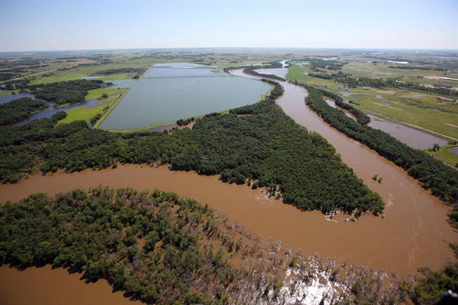
About 2,000 square kilometres of valley lands flooded as the Red River rose 12 metres above winter levels.

According to the City of Winnipeg, at the crest of the flood, the Red River flow approaching Winnipeg was 138,000 cubic feet per second – enough water to fill the city’s Pan Am Olympic Pool once every second.
About 3,000 military personnel were dispatched after a local state of emergency was declared.
More than 9,000 people were evacuated from their homes in Winnipeg. The total cost of the flood was estimated to be $51 million.
2. Winnipeg, Manitoba, 1950
Heavy snowcover was also to blame for creating one of the worst floods in Manitoba’s history. Flood levels were reached by April 22, and in early May, Winnipeg received twice the normal amount of rainfall for the month. For 51 days, the Red River remained above the flood stage.
People had to tackle water that was 4.6 metres deep in some parts. The water forced about 60,000 people to flee their homes, though dikes were able to keep an additional 4,700 homes dry.

Get breaking National news
Fortunately, only one person – a volunteer pump operator – died during the flood. The total cost of the flood was about $125.5 million (in 1957 dollars).

3. Manitoba floods of 2009
The flood of 2009, like many others, was helped along by the previous winter.
In November 2008, heavy rains soaked the southern province. Then the cold winter helped keep that moisture in the ground. On top of that, the northern U.S. experienced an above-average snowpack that winter as well.

When the rains rolled around in the spring, the ground was already saturated and unable to absorb much more. As well, ice jams helped to raise the Red River almost 3 metres overnight at one point, to record levels. On April 16, the river crested in Winnipeg at 6.9 metres, just 0.6 metres lower than that of 1997.
4. Manitoba floods of 2011
Similar to the floods of 2009, the floods of 2011 were helped by fall rain and a cold winter.
By early April 2011, the province declared a high flood risk for the Red, Assiniboine, Souris, Pembina and Qu’Appelle rivers as well as several lakes. By May 9, a province-wide state of emergency was issued.
As in the summer flood of 2014, Brandon was at the centre of the flood battle. The Assiniboine River reached its highest level since 1923 and was about 20 to 30 times wider than normal in some places and seven metres higher.
The 2011 flood produced the highest water levels and flows in modern history across both Saskatchewan and Manitoba.

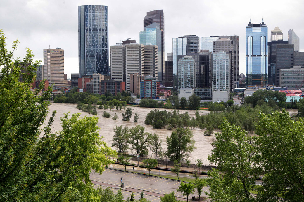
5. Calgary floods of 2013
The most recent flood in the minds of Canadians (aside from the ongoing floods in Saskatchewan and Manitoba this summer) was the devastating floods in southern Alberta in 2013.
About one-quarter of the province was affected, including the city of Calgary.
A storm system parked itself over the region on June 19. The rain continued for almost 18 hours in some part, with no end in sight. Over the Rockies, instead of the precipitation falling as snow – where the ground could slowly soak it up – it fell as rain, saturating the ground.
In Calgary, 68 mm of rain fell over 48 hours. But west of the city, the headwaters of the Bow and Elbow rivers were dealing with torrential rainfall. Totals averaged 75 mm to 150 mm over two-and-a-half days. West of High River, Burns Creek recorded an astounding 345 mm; Canmore recorded 200 mm, ten times that of their entire summer rainfall.
Floods and landslides closed off part of the Trans-Canada Highway. In Calgary, 4,000 businesses were impacted. The Calgary Zoo moved many of its exotic animals to its ranch south of the city, more than two metres submerged Stampede Park.
The flood was estimated to exceed $6 billion in damage losses and recovery costs.
Another flood of note is the Qu’Appelle River Flood in Saskatchewan in 1974. The melting snowpack was to blame as more than 1400 people were evacuated in Moose Jaw when the Moose Jaw River, Thunder Creek and Spring Creek all overflowed their banks. About 60 blocks throughout the city were flooded.
Comments