
Watch above: Jackson Proskow explains why continued flooding on the Don Valley Parkway will require costly infrastructure upgrades.

TORONTO – On Wednesday night the Don Valley Parkway flooded. Again.
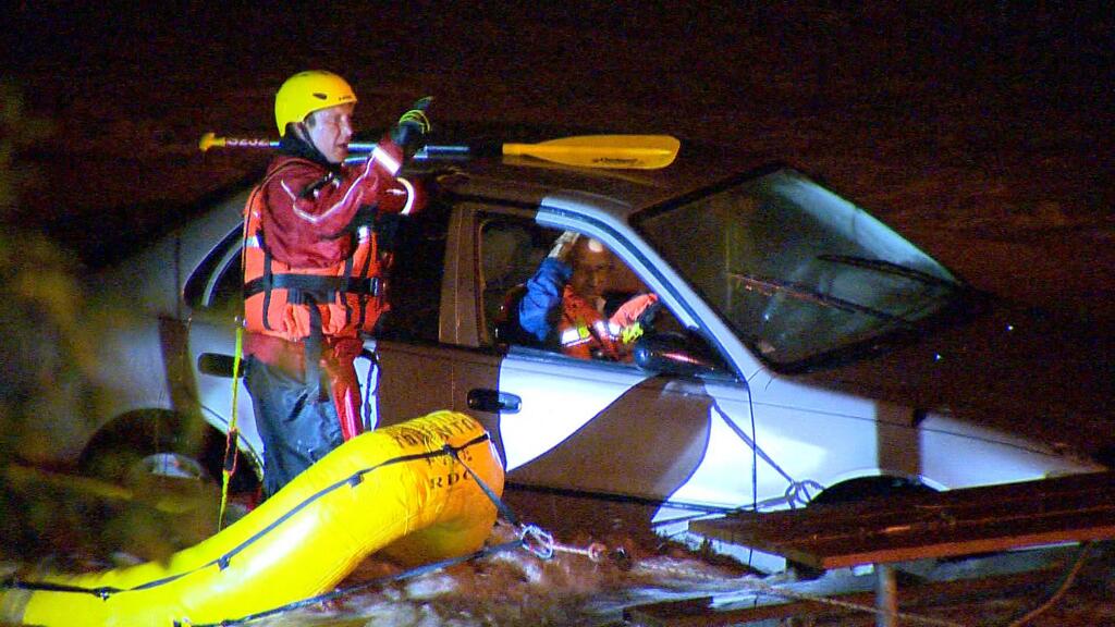
It seems as though every major rain storm in Toronto shuts down the DVP south of Dundas. Images of cars wading through metre-deep water, or drivers being rescued by Toronto Police in rafts seem to be no big surprise anymore.
But why is it happening?
Anatomy of a storm
By 6 p.m. Wednesday, a line of rain had developed from southwest to northeast, right through the city, likely fuelled by lake breezes off Lake Ontario.
By around 6:30 p.m. it appeared as though the system was collapsing and that the showers were going to come to an end.
But they didn’t.
Instead, the system redeveloped – and it remained parked over the city, almost hugging the city limits perfectly to the north at Steeles Avenue.
At 6:45 p.m., Environment Canada – realizing that the storm system was nearly stationary – issued a special weather statement calling for 30 to 40 mm of rain.
The rain continued to fall, and as it did, the ground – already soaked from days of rain – couldn’t absorb the sudden onslaught.
Once again, the Don River crested onto the DVP.
Watch: Anthony Farnell explains why Wednesday’s storm led to flooding in the GTA.
Too close for comfort

Get daily National news
“In the Don River Watershed we have two major tributaries – the east Don and the west Don,” Laurien Farrell of the Toronto and Region Conservation Authority said. “And they come together just upstream of Pottery Road. So all of the water from upstream in Richmond Hill, Markham, northern parts of Toronto have to come through this one single channel.”
Farrell explained that, with heavy rain events like this, the water has nowhere to go. It tries to flow into the lake, but gets backed up.
And the DVP, which sits almost flush with the Don River, becomes the logical path for that water.
“Most people don’t usually look to their right as they’re driving down the bottom part of the DVP, but it’s literally built right beside and almost on top of the Don River, and only a few feet higher,” Ryan Ness of the TRCA said. “So it doesn’t really take that much extra water to come down the Don to flood the parkway.”
When the DVP was built, existing roads and railways, including some factories and homes, likely made the area more appealing for the construction of a highway, Ness said.
“Nobody ever really anticipated that development of Toronto at the scale that it has, so all of that pavement creates a whole lot of runoff that never really went down the Don River before,” Ness said. “So now the flow conditions at the Don River are significantly different than they were when the DVP was built.”
So on top of the water flowing down the two tributaries into the Don River, all the runoff from the concrete jungle that is Toronto ends up in the Don River which is unable to handle such a deluge.
As for Wednesday night’s storm, Environment Canada wasn’t anticipating the system to park itself over the city the way it did.
“We knew the showers that were going to occur were not going to be moving all that fast. But this idea of regeneration was something that was not anticipated leading up to it,” Coulson said. “So some other local effect was at play that I don’t think we’re really fully aware of,” Coulson said.
Like the flood of July 8, 2013, one of the costliest natural disasters for Toronto, Wednesday’s rainfall varied widely across the region.
Buttonville Airport in Markham, just north of the city, received barely over a millimetre of rain. At the Environment Canada office in Downsview, 35 mm of rain was recorded. But about a kilometre away, at G. Ross Lord Park, near Dufferin and Finch, the TRCA gauge measured over 50 mm.
“This was intensely localized precipitation, falling in a watershed that is urbanized,” Coulson said. And that rain ends up running off into our most vulnerable, low-lying areas.
“Unfortunately, one of the vulnerable areas tends to be one of our major highways in the area,” he said.
“These types of events, localized heavy precipitation, are going to continue to be a challenge as we go forward.”
Watch: The DVP flooded once again on Wednesday night.
Moving forward
Are there solutions to the DVP flooding problem?
Farrell said that such solutions could include raising the DVP or the Metrolinx train tracks, but these solutions provide their own challenges, such as closing off a major artery into the city.
“It’s definitely not cheap, and it’s definitely not going to be an easy task,” she said.
“There are solutions. But they’re just going to take time to plan them properly, to get the funds in place, and recognize that we can’t necessarily solve all our problems.”


Comments
Want to discuss? Please read our Commenting Policy first.