

Winter is making a comeback on the Prairies, with cold temperatures and heavy snow slamming into the region over the next few days.

In Calgary, Lethbridge and much of southern Alberta, a winter storm warning was in effect Tuesday, with the high temperatures expected to hit just -15 C in Calgary and -17 C in Edmonton before plunging to -23 C overnight.
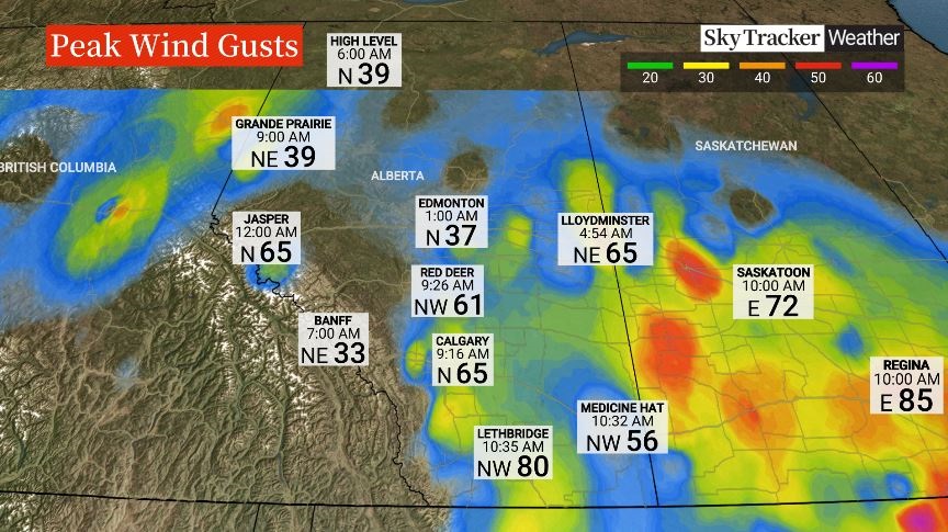
The cold was also accompanied by strong wind gusts, making the temperature feel closer to -30 C, prompting warnings that frostbite is possible within minutes on exposed skin.

The snow and blowing snow also created reduced visibility that made driving difficult in many areas.
Along the QE2, the main highway between Calgary and Edmonton, the RCMP warned of “very poor” driving conditions, including one chain-reaction collision that shut down the southbound lanes of the highway near Didsbury, about an hour north of Calgary.

“A powerful weather system that developed over Montana swept into Alberta Monday night, bringing widespread snowfall and strong winds across much of the province,” said Global Calgary weather specialist MacKenzie Mazankowski.

Get daily National news
“Most areas received between 10 to 20 centimetres of snow, with the potential for a few additional centimetres or even another significant round of snowfall before the day is over.”

“By afternoon, the system will begin pushing into Saskatchewan, delivering similar conditions including heavy snowfall and gusty winds,” said Mazankowski.
While Saskatchewan isn’t forecast to experience the same frigid temperatures as Alberta, much of the province is under a snowfall warning, with some areas forecast to get up to 35 cm by the time the show tapers off Thursday morning.
Daryl Massie, roadways operations manager for the City of Regina, said the city already had crews out Tuesday morning preparing streets for the arrival of what is expected to be the biggest storm of the winter so far, but his biggest concern is the forecasted wind gusts of up to 80 kilometres per hour.
“Once the initial snow starts, we will go into storm mode, basically ice control and trying to keep the streets open as much as we possibly can, keep emergency routes open, those type of things,” said Massie. “Once the snow stops we will will go into our systematic plowing.”
-
![]() Health Matters: Improving breast radiotherapy for every body
Health Matters: Improving breast radiotherapy for every body -
![]() Surrey Police to take over for RCMP in Cloverdale on April 1
Surrey Police to take over for RCMP in Cloverdale on April 1 -
![]() Vancouver addictions doctor says World Cup visitors should be warned about Vancouver’s toxic drug supply
Vancouver addictions doctor says World Cup visitors should be warned about Vancouver’s toxic drug supply -
![]() Health Matters: Cheese included in certain Hello Fresh meal kits recalled
Health Matters: Cheese included in certain Hello Fresh meal kits recalled


Environment Canada is also warning that drivers should be prepared for “quickly changing and deteriorating travel conditions” and says “non-essential travel should be avoided.”
The nasty weather will also spread into southern Manitoba, where a snowfall warning is in effect beginning Tuesday evening.
“The heaviest snowfall is expected along the Manitoba Escarpment and across the higher terrain of the Parklands region, where totals could reach up to 30 cm,” said Mazankowski. “In other areas, snowfall amounts will generally range between 15 and 25 cm.”
A total accumulation of up to 25 cm is expected in the Winnipeg area before the snow tapers off Thursday morning.
The temperature in the Winnipeg area is only forecast to hit the mid-minus-teens so the weather won’t be as unpleasant as it is farther west, although Environment Canada warns that travel conditions will be difficult.
The winter weather has also prompted Canada’s major airlines, including Air Canada, Westjet and Porter Airlines to issue travel advisories warning delays and cancellations and recommendations that travelers check the status of their flight before heading to the airport.
By late Tuesday morning Calgary International Airport had already confirmed 27 cancelled flights.
“Looking ahead, there is some relief on the horizon,” said Mazankowski.
“Temperatures in Alberta are expected to gradually moderate by the weekend, with a steady climb continuing into next week and potentially rising above the freezing mark by the end of the week.
With files from The Canadian Press.
So, Alberta’s suffering from a Montana Clipper.