
Environment Canada says another dumping of snow is on the way for Quebec, while Ontario is expected to see a significant drop in temperatures this week.

Global News meteorologist Ross Hull said a “potent cold front” is moving across southern Ontario on Wednesday.
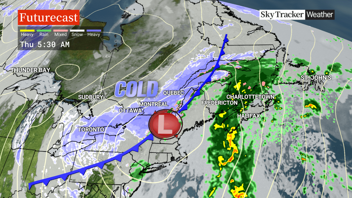
“After a January thaw over the last few days with above average temperatures, this front will usher in a dramatic change across Eastern Canada over the next couple of days,” Hull said.
Environment Canada forecasts temperatures are expected to drop sharply by Thursday.
“Thursday will be the coldest day of the season so far with daytime temperatures remaining in the minus double digits and wind chills into minus twenties or lower,” Hull said.
Toronto is forecast to see -2 C on Wednesday afternoon and dropping to as low as -12 C by the evening hours, but feeling more like -22 with the wind chill overnight into Thursday morning.
Significant snowfall is also expected: Environment Canada is warning of 10 to 20 centimetres of snow to fall between Wednesday evening and Thursday afternoon, with the snow tapering off come the evening.

Get daily National news
The traditional snowbelt areas towards Lake Huron and Georgian Bay are under a yellow snow squall warning, with 15 to 30 cm of snow expected from Wednesday afternoon to Thursday afternoon.
“Cold conditions mean this will be fluffy snow, blowing around easily and reducing visibility,” Hull said.
Rapidly falling temperatures are also expected over northern Grey County to near Stayner.
“As the cold front stalls over the area, even the GTA and much of southern Ontario have the potential for some heavy bursts of snow Wednesday night into Thursday morning, which could have a significant impact on the Thursday morning commute,” he continued.
More north, in the Sudbury area, temperatures are expected to fall as low as -33 with the wind chill on Thursday morning. Environment Canada warns of a risk of frostbite.


At the tip of southern Ontario, from London towards Sarnia, another snow squall warning is in place, dumping the same amount of snow. The weather agency said the highest snowfall amounts are expected to be over eastern Lambton County and western Middlesex County towards Grand Bend.
Meanwhile, in southwestern Quebec, the area in and around Montreal is under a yellow snowfall warning and is “in line for a dramatic downward temperature trend” by Thursday.
Snow is expected to fall from early Thursday morning until the evening hours. The Montreal area is forecast to get another 10 to 15 centimetres of snow, coupled with blowing snow.
“Rain will turn to snow overnight as temperatures drop below the freezing point. Untreated surfaces could become icy and snowy. Snow will be heavy at times, which could have a significant impact on traffic during rush hour,” the warning read.
Towards the east, Hull said the Maritimes will stay with milder air for the next couple of days. Rain is expected to be heavy at times for southern New Brunswick and Nova Scotia on Thursday. Colder air will then move in by Friday, with the possibility of heavy bursts of snow for some areas.
Comments
Want to discuss? Please read our Commenting Policy first.