Unusually mild weather has overtaken much of southern Ontario on Friday with double digit temperatures expected for several cities including Toronto, according to Global News meteorologist Ross Hull.

Hull says temperatures overall have already been well above average so far for February with warm weather set to peak for Friday.
“A Colorado Low is moving into northwestern Ontario and southern Ontario and the Greater Toronto-Hamilton Area are in the warm sector of the low which is pumping in warm air from the southern U.S. into the Great Lakes,” Hull said.
Hull said cities such as Toronto, Windsor, London and Hamilton will see temperatures rise to double digits likely surpassing previous daily highs.
He said the daily record to beat in Toronto, at Pearson airport, is 10.6 C set back on Feb. 9, 1938.
As of 10 a.m. Friday, Toronto Pearson Airport recorded the temperature at 11.4 C — officially breaking the day’s record at this time.

By 11 a.m., temperatures continued to soar with the airport logging 13.2 C. By 1 p.m., the temperature reached 14.4 C.

Get daily National news
Although Friday will feel unusually warm, it will not be the warmest it’s ever been on record in February for Toronto. On Feb. 23, 2017 it reached 17.7 C which was a record for the month.
Hull also said another factor to just how warm the temperature gets on Friday will be how much sunshine develops in the afternoon as there is expected to be some breaks in the cloud cover letting in the sunshine.
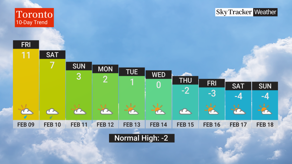
Hull’s 10-day weather trend for Toronto shows Friday to be the warmest of the days, with a high of 7 C on Saturday and a high of 3 C on Sunday. Rounding out the ten days, below freezing temperatures of around -4 C.
The next couple of days will see the chance of showers, even the risk of an isolated thunderstorm, Hull said. However, the brunt of the precipitation with this system will move into northern Ontario instead of southern Ontario which is not expecting to see significant amounts of rain, Hull said. Most areas can expect around 5 to 10 mm by Sunday.
“Temperatures will return to more normal February values as we move into next week,” Hull said. “That will likely be the pattern into the end of the month with even some bouts of below average temperatures as arctic air descends back into the Great Lakes at times.”
The short stretch of warm weather comes just after frigid temperatures moved into Ontario for a portion of mid-January. Temperatures had dropped to below -20 with the wind chill.
Meanwhile, across the country, most regions are also expecting to see above normal temperatures for this time of year.
The Insurance Bureau of Canada (IBC) is also warning Ontarians about the “mid-winter thaw” due to risk of possible damages to their property.
“With a warm-weather system quickly moving into Ontario this week, especially through the northern regions of the province, there is potential for significant snowmelt, ice jams and flooding,” said Amanda Dean, a vice-president with the IBC.
“It is important that property owners and renters take necessary precautions and protect their properties to minimize potential damage,” Dean said.
Some tips from the IBC include mitigating the impacts of flooding by keeping basement floor drains clear, moving valuables out of basements into higher levels, and making sure downspouts are clear of debris. They are also remind residents to prepare for power outages.


Comments