
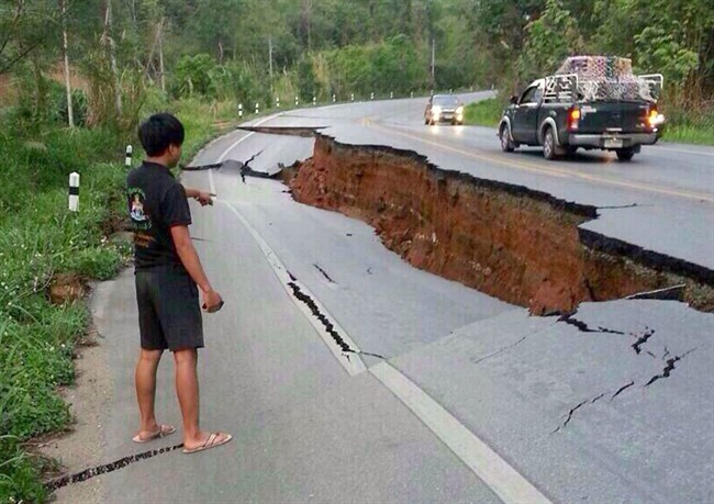
TORONTO – Twitter was littered with reports of damages and harrowing tales of shaking buildings following a magnitude 6.3 earthquake felt across northern Thailand and Myanmar Monday.

READ MORE: Earthquake cracks walls, roads in north Thailand
Many users took to the social networking site to report heavy shaking during the quake and shared pictures of cracked roads and damaged buildings following the tremors.
But this type of information sharing could prove more useful than ever before.
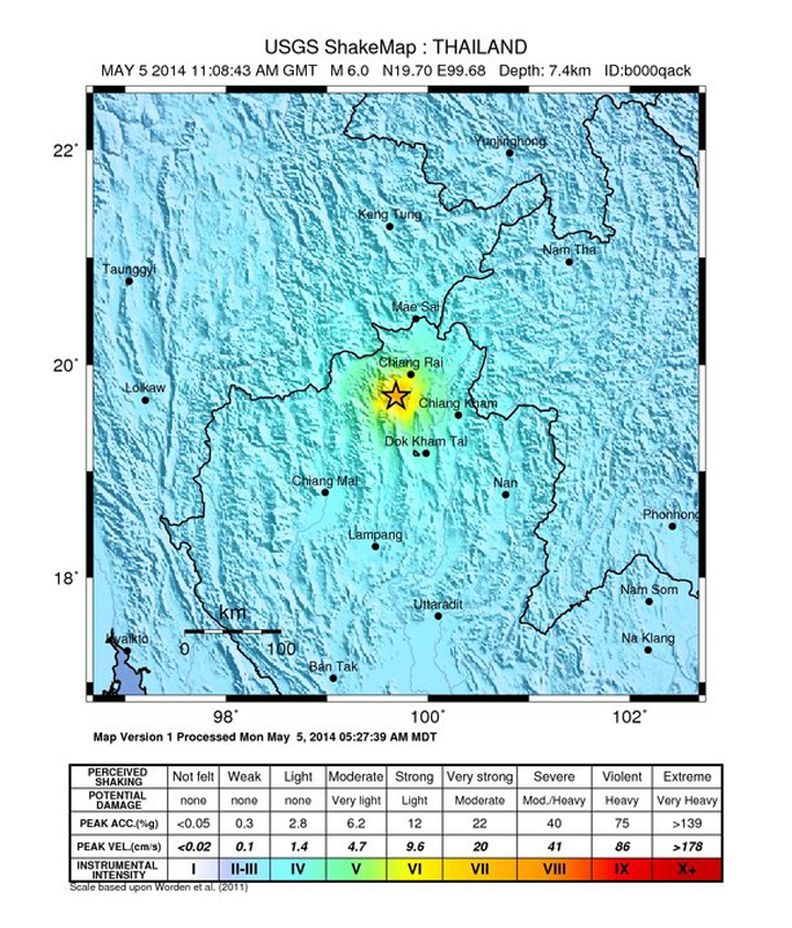
Researchers at Stanford University are using tweets to add more accurate real-time information to ShakeMaps, created by the U.S. Geological Survey (USGS) Earthquake Hazards Program to track earthquakes.
Through a series of studies, researchers found that by including data pulled from real users’ tweets about seismic activity alongside traditional earthquake measuring data the USGS would be able to create more accurate ShakeMaps.
ShakeMaps are produced using seismic recordings and geological data from the site of the earthquake. They are then enhanced by witness accounts – referred to as “Did you feel it?” data – collected by online surveys.
The maps are used for post-earthquake response and recovery operations and are studied for disaster planning purposes.
- Ont. First Nation calls for chemical plant to be shut down amid ‘dangerously high’ benzene levels
- Ottawa looks to launch national flood insurance program within 12 months
- Nova Scotia scraps spring bear hunt idea, public ‘very divided’ on issue
- Ecuador rations power, declares emergency as drought limits hydro output
The problem with this model is that witness data can take a while to collect.
Twitter, on the other hand, allows users to immediately share information about an earthquake.
To gather the data, researchers looked at geo-tagged tweets that included the words “earthquake” or “tsunami” posted within the first 10 minutes of Japan-based earthquakes measuring over magnitude 6 from 2011 to 2012.


The tweets were also examined to see the number of times the keywords were mentioned, if the users included emjoi’s, or if they used distinctive punctuation like exclamation points.
READ MORE: Is Twitter an Earthquake Detector?
All of these factors help provide information as to how the earthquake impacted certain areas around the epicentre.
“This is important because additional data sources such as on-the-ground inspections by engineers, measurements from recording stations not connected to the internet, and online surveys such as “did you feel it?” may not be available before some decisions about relief aid need to be made,” read the report.
Researchers added that the approach could have significant potential for areas that don’t have many earthquake recording stations but have a large population of active Twitter users.
That being said, this kind of data collection would only work well in areas with high Twitter use.
Though tweets are not currently being used in creating ShakeMap data the USGS is examining the use of tweets in a number of areas, including rapid earthquake detection.
The Stanford research will be presented at the National Conference On Earthquake Engineering in July.
Comments