

Hurricane and tropical cyclone watches have been issued in parts of Nova Scotia and New Brunswick as Hurricane Lee continues on its path toward eastern Canada.

As of noon Thursday, Lee was about 1,650 kilometres south-southwest of Halifax, moving north around 22 km/h, with maximum sustained winds of 150 km/h, making it a Category 1 hurricane.
Bob Robichaud, warning preparedness meteorologist with Environment Canada, said Lee will arrive in the Canadian Hurricane Centre’s response zone Friday, before taking aim at western Nova Scotia and into the Bay of Fundy area.
While Lee’s exact trajectory is still up in the air, Robichaud said “confidence is increasing” that the storm will make landfall in western Nova Scotia or along the Fundy coast of New Brunswick Saturday night.
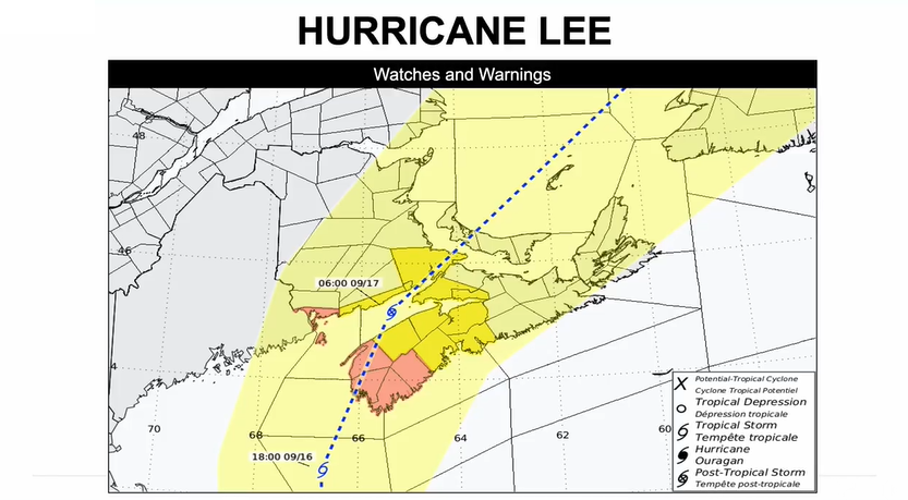
Hurricane watches are in effect for Grand Manan and Coastal Charlotte County in New Brunswick, and Digby, Yarmouth, Shelburne, and Queens Counties in Nova Scotia.
Tropical storm watches are also in effect for Saint John County, Fundy National Park, and Moncton and Southeast New Brunswick, as well as Annapolis, Kings, Lunenburg, and Hants Counties, Halifax Metro and Halifax County West, Cumberland County – Minas Shore, and Colchester County – Cobequid Bay in Nova Scotia.

In a 3 p.m. update, the Canadian Hurricane Centre said the watch “will likely be upgraded to warning tonight.”

Get daily National news
Robichaud noted that hurricane watches are for areas with a potential of winds exceeding 118 km/h, while tropical storm watches are for areas with a potential of winds in excess of 63 km/h.
“It will be important to watch for any changes in those watches — whether they’re upgraded to warnings or whether they’re expanded, depending on the track of the storm,” he advised.
The meteorologist also said a lot of rain is expected, with a system dumping rain over the region Thursday and Friday before the storm, and more expected during the storm itself.
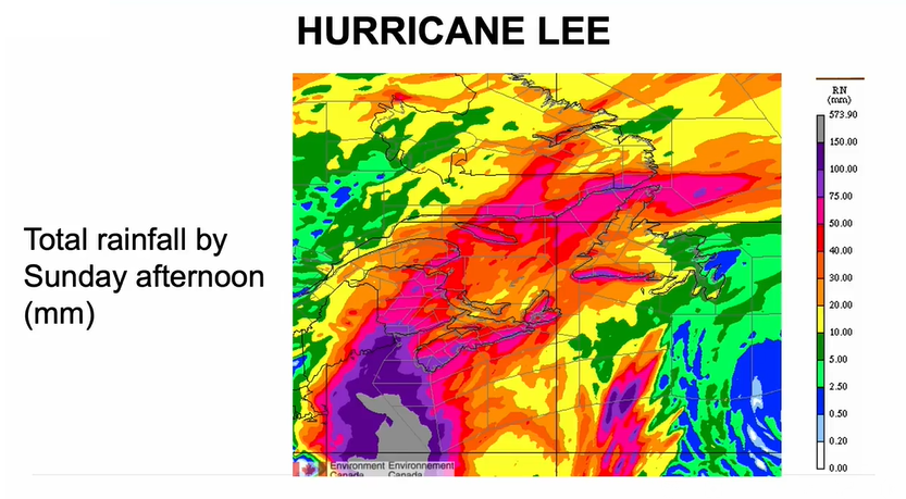
“We know that rainfall is potentially going to be an issue with this storm, especially with all the rain that we had over the course of the summer,” Robichaud said.
“We’re talking about amounts that could exceed 100 millimetres in the extreme western parts of Nova Scotia and southwestern New Brunswick by the time this is all said and done.
“But for other areas, we’re looking at amounts that should be certainly less than that.”

He added that based on the current track, the heaviest rainfall should stay in the Gulf of Maine area, just to the west of Nova Scotia and southwest of New Brunswick — but that could change if Lee’s track shifts.


“If we get a migration of the track a little bit further east, that brings a larger area in play for the heavier rainfall, so that’s what we’re going to be watching as well,” he said.
In terms of storm surge, Robichaud expects to see waves reaching the coast later Thursday and into Friday, continuing to grow into the next couple of days.
“We’re expecting the highest waves to occur along the Atlantic coast of Nova Scotia, potentially into the Bay of Fundy area of New Brunswick,” he said.
“In terms of any kind of coastal impacts, we have to wait to see how this storm surge is going to coincide with the tide of the day.”
But the meteorologist said there shouldn’t be a “major problem” with the Chignecto Isthmus, a vital land corridor linking Nova Scotia and New Brunswick, which is at risk of coastal erosion.
“Given the track that we’re looking at right now, it doesn’t look too too bad,” he said, adding that we are not in the period of the month where tides are the highest.
“Certainly it’s something we’re always watching, but given the intensity of the storm and given the storm track at this point, it doesn’t appear to be something too, too severe at this time.”
‘Nothing’ like Fiona
Robichaud also said Lee won’t cause the same level of damage and destruction as post-tropical storm Fiona did last year.
While Lee is very large in size, Robichaud said the angle of approach is different and it has had time to weaken.
“Really, the storm has a lot of cold water to travel over by the time it gets here,” he said. “In terms of intensity, (it’s) nothing like we saw with Fiona last year.”
Lee is the 12th named storm of the Atlantic hurricane season, which runs from June 1 to Nov. 30 and peaked on Sunday.
The National Ocean and Atmospheric Administration in August forecast between 14 and 21 named storms this season. Six to 11 of them are expected to become hurricanes, and of those, two to five might develop into major hurricanes.
— with files from The Associated Press
Comments
Want to discuss? Please read our Commenting Policy first.