
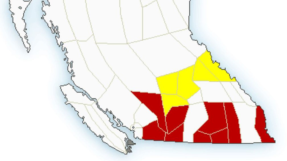
Snowfall and winter storm warnings have been issued for mountain passes in B.C.’s Southern Interior.

According to Environment Canada, heavy snowfall accumulations are forecast for Highway 3 and the Coquihalla Highway from Saturday through to Sunday morning.
For Highway 3, 15 to 20 cm is projected between Hope to Princeton, while 30-40 cm is projected to fall between Paulson Summit and Kootenay Pass.
For the Coquihalla, 25-35 cm is in the forecast between Hope and Merritt, though that section of the popular highway is closed as crews repair several sections that were damaged from flooding last month.
The national weather agency also noted that southwest winds of 50 km/h gusting up to 70 could also create blowing snow.
“A Pacific frontal system is giving snow to the B.C. Interior,” said Environment Canada. “Snow at times heavy will continue to Sunday afternoon with total accumulations of 30 to 40 (cm) expected.

Get breaking National news
“In addition, near-zero visibility is possible in blowing snow due to strong winds today and tonight.”

Heavy snowfall is also expected in the Kootenays.
In the Arrow Lakes and Slocan Lake region, 15-20 cm is expected, as cold front arrives and stalls over the region, resulting in narrow bands of heavy snow.
“Any community under these bands will experience heavy snow while light accumulation of snow or even light rain will occur a few kilometres down the road,” said Environment Canada.
In the Elk Valley region, Fernie and Morrisey are expected to receive 30-40 cm, while 15-25 cm is forecast for Sparwood.
- After experiencing 2016 wildfire, Fort McMurray survivor addresses evacuation trauma
- Edmonton organizations watch out for seniors during hot, smoky conditions
- Calgary air quality on Friday among the worst cities on earth
- Thorhild, Westlock counties declare state of agricultural disasters due to rain


“Consider postponing non-essential travel until conditions improve. Rapidly accumulating snow could make travel difficult over some locations. Visibility may be suddenly reduced at times in heavy snow.”

Snowsquall warnings are also in effect for the North Columbia, North Thompson, South Thompson and Kinbasket regions.
“A cold front transiting across the B.C. Interior will bring strong winds and brief bursts of heavy snow that will create hazardous conditions with sudden reduction in visibilities,” said Environment Canada.
“Those in the area are advised to be sky aware and prepare for the possibility of these hazardous conditions if travelling or recreating outdoors.
Environment Canada says snow squall watches are issued when conditions are favourable for brief but intense bursts of heavy snow producing near-zero visibilities.
For the latest road conditions throughout the province, visit DriveBC.

Comments
Want to discuss? Please read our Commenting Policy first.