

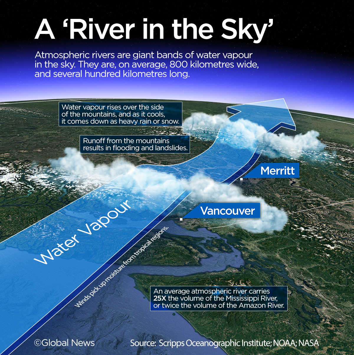
High up in the atmosphere, giant bands of moisture several hundred kilometres long work like giant fire hoses in the sky.

They are the biggest rivers on Earth — but to the naked eye, these so-called atmospheric rivers are completely invisible.
They pump 25 times the flow of the Mississippi River, or two times the flow of the mighty Amazon, across the Pacific Ocean, from the tropics, toward the West Coast of Canada and the United States.
This week, just a fraction of that water came crashing down over the mountains and valleys of British Columbia, causing widespread flooding in communities like Merritt and Princeton, and triggering several landslides.
For Marty Ralph, a meteorologist and storm chaser with the Scripps Institution of Oceanography in San Diego, tracking atmospheric rivers — and finding out how they are going to affect people on the ground — is his life’s work.
“I became more and more convinced it was the type of storm that we really needed to better understand, and better observe and better predict,” he said.
The fingerprints of climate change are all over what is happening, according to weather specialists and atmospheric scientists.
As oceans get warmer, more water vapour is released into the atmosphere, says University of British Columbia atmospheric scientist Rachel White. More water vapour, in turn, causes atmospheric rivers to be ‘wetter,’ leading to more potential chaos on the ground when all that moisture comes down as rain, she adds.
With the climate emergency getting worse, being able to better forecast the weather, therefore, has real impacts on people and property.
“It’s a tough business to improve weather prediction,” according to meteorologist Marty Ralph.
But that’s changing.
Five years ago, Ralph spotted a unique opportunity to work with the U.S. Air Force. He successfully requested two C-130 aircraft normally used to track hurricanes, and now, those planes, along with a third hurricane hunter plane, are part of a growing arsenal of storm tracking technology used for “atmospheric river reconnaissance.”
In other words — very high-altitude storm tracking.
‘A parade of storms’
Over the weekend and into Monday, a staggering amount of rain fell on parts of B.C., forcing thousands of people to flee to drier ground. The entire city of Merritt was put on an evacuation order. The community of Hope received 174 millimeters on Sunday.
“Many places are equaling or surpassing their average monthly precipitation,” and that’s in a span of a day or two, says Bobby Sekhon, an meteorologist with Environment Canada.
These extreme downpours are the latest string of weather events in what has already been a very soggy fall on the already wet West Coast.

Get breaking National news
A Pineapple Express, as an atmospheric river is colloquially called, is a familiar term to many people in BC.
These storm systems originate in tropical regions of the Pacific, often near Hawaii, thus the reference to pineapples.
But what is different is just how many of them there have been. This season, there have been five such bursts of intense, wet weather — and it’s only November.
“It has been extraordinarily active this year,” he says.

With climate change, these types of weather events are only going to get more and more common, according to atmospheric scientists.
“Over the next 30, 40 years, we should expect to see more heat extremes, we should expect to see more intense atmospheric rivers, and so when they do come, they’ll be stronger,” says Dr. White.
‘Supercharging’ a storm
The residents of Merritt, B.C. don’t have to wait that long to see the impacts of more extreme weather.
They’re already living it.
The atmospheric river that brought record rain on Monday was classified as a level-four weather event on a five-point scaling system. “Imagine supercharging that” with more water vapour, says Marty Ralph. That’s a distinct possibility with global warming, he cautions.
More and more Canadians are taking stock of this new reality. That includes Merritt resident and evacuee Michael Reeve.
“Hopefully an event like this will finally stir some action,” he told Global News Radio’s Jas Johal Show.
“We say it’s a wakeup call, and then, how many times in the past have we said a big event is a wakeup call, and then next year we forget about that wakeup call and there’s another wakeup call?”


Floods and landslides
Over the ocean, atmospheric rivers don’t cause a lot of damage. But the bands of moisture run up along the mountains and the coast and all that water vapour then comes down in the form of rain.
That rain can be intense — and unrelenting.
The mayor of the town of Princeton, B.C., says the floods happened so fast, they barely saw it coming.
Then there are the landslides.
Slides, says Brett Gilley, a natural disaster specialist and geologist, are triggered by a “constant battle between the mountains going up, and gravity bringing them down.”
“It’s literally boulders and trees that are barreling towards you.”
Ironically, the intense heat dome that baked the Pacific Northwest this summer likely made the situation even more precarious, as root structures for trees that hold soil and rock back were weakened during the heat event, Gilley says.
“So all of these things feed into each other, and that’s what we’re starting to be concerned about.”
Tracking storms
The silver lining in the cloud — literally — is that meteorologists are getting better at tracking atmospheric rivers, and the rainfall events associated with them.
But these improvements require flying above storm systems to study fast-moving weather patterns.
Much like in hurricane hunting, scientists use tiny sensors dropped from aircraft that cascade over the aerial rivers. The missions are “super exciting and revealing,” says Marty Ralph, of the Scripps Institution.
The sensors are about the size of a can of pop, and are dropped into the belly of the storm using tiny parachutes. This process allows researchers to measure temperature, pressure, wind and moisture, and then relay that information via satellite to observatories on the ground.
“We release roughly 100 of these measurements, slicing and dicing across the atmospheric river,” Ralph says.
The upside of this work? Improvements to weather forecasting on the West Coast — and more accurate warnings for communities in the storm’s path.
But the new climate realities associated with these storms are also a reminder for communities that have to deal with floods and landslides, according to geologist Brett Gilley.
“We’re going to have to adjust how we rebuild, and what we do in the future,” he says.
“We’re not going to stop the mountains from falling down.”
Comments
Comments closed.
Due to the sensitive and/or legal subject matter of some of the content on globalnews.ca, we reserve the ability to disable comments from time to time.
Please see our Commenting Policy for more.