
Another ‘atmospheric river’ is expected to drench B.C.’s South Coast this weekend, with heavy rain in coastal areas and snow at higher elevations.

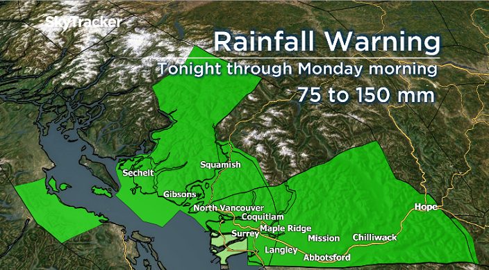
According to Environment Canada, the Lower Mainland, lower Fraser Valley, Howe Sound, east Vancouver Island and southern parts of the Sunshine Coast could see 75 to 150 millimetres of rain.
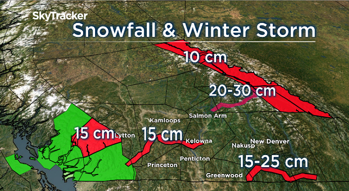
In the Southern Interior, heavy snow is expected starting Saturday night along stretches of highways at higher elevations.
The weather agency says it expects freezing levels will climb 2,000 metres by Sunday morning, when snow is expected to become rain.
“An intense Pacific frontal system moving across the B.C. Interior will give snow to most southern highway passes,” said Environment Canada.
“Light snow from the system will become heavier later (Saturday) evening and will persist into Sunday morning. Total snow accumulations of 15 to 25 cm can be expected before the snow changes to rain midday Sunday.”
Environment Canada issued its snowfall warnings early Saturday, and they include:
- The Sea to Sky Highway (Squamish to Whistler, 15 cm)
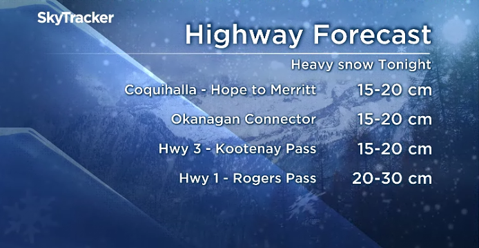
- The Coquihalla Highway (Hope to Merritt, 15 cm)
- The Okanagan Connector (Merritt to Kelowna, 15 cm)
- Highway 3 (Paulson Summit to Kootenay Pass, 15-25 cm)
- The Yellowhead Highway (10-20 cm)

A winter storm warning was also issued for the eastern half of the Trans-Canada Highway (Eagle Pass to Rogers Pass), where 20-30 cm of snow is expected — along with hazardous conditions — before the snow changes to rain later Sunday.

Get daily National news
The national weather agency noted that motorists should adjust their driving to the road conditions, that visibility may be suddenly reduced at times in heavy snow.
Regarding the rainfall warning, Environment Canada said the weather event “will bring copious amounts of rain and near-record temperatures to the B.C. south coast beginning late (Saturday) afternoon. As the warm front approaches, steady rain will develop late (Saturday) afternoon.”

Rain is expected to be heaviest Sunday afternoon and Sunday night ahead of the cold front. The heavy rain will ease on Monday as the cold front pushes the precipitation out of the region.
“The lowlands of Metro Vancouver will see up to 75 mm of rain by Monday while the North Shore, Northeast sector including Coquitlam and Maple Ridge and Fraser Valley west, including Abbotsford, could see up to 100 mm,” said Environment Canada.
“Howe Sound and central and eastern Fraser Valley including Chilliwack and Hope could see upwards of 150 mm.”
Read more: Category 4 Atmospheric River hits B.C. coast: What is it and what does it mean? (January 2020)
The weather agency said this could result in possible washouts, debris flow and pooling water as rising freezing levels will also melt snow at higher elevations. Local river levels will rise and river flows will increase as a result of the heavy rain.
For the latest highway conditions, including webcams, visit DriveBC.
— With files from The Canadian Press


Comments
Want to discuss? Please read our Commenting Policy first.