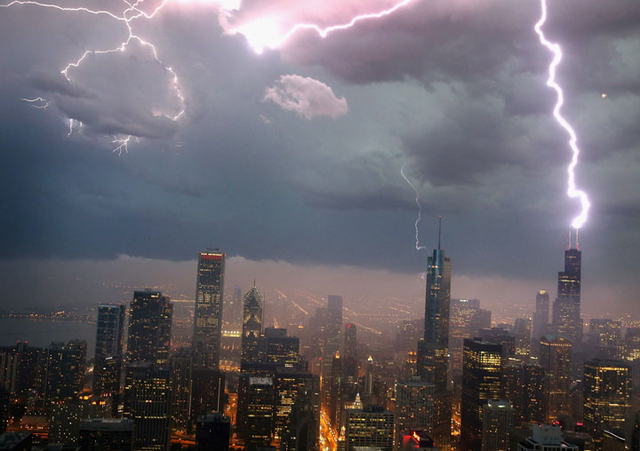
CHICAGO – A massive storm system originally forecast to affect one in five Americans from Iowa to Maryland surged Thursday toward the Mid-Atlantic after largely failing to live up to its billing in ferocity through the Upper Midwest.

Authorities in Ohio reported early Thursday morning that high winds from possible tornadoes had damaged barns in the northwest and knocked out power in some areas in the centre of the Buckeye State.
Meteorologists warned about the possibility of a weather event called a derecho (deh-RAY’-choh), which is a storm of strong straight-line winds spanning at least 240 miles.
By early Thursday, a derecho hadn’t developed. And Greg Carbin of the National Weather Service’s Storm Prediction Center in Norman, Okla., said, “With each hour that goes by, it’s less likely.”
While the Midwest dodged a derecho, several tornadoes, large hail and flooding did some damage.
In the small town of Belmond, Iowa, about 90 miles north of Des Moines, Duwayne Abel, owner of Cattleman’s Steaks & Provisions restaurant, said a tornado demolished part of the building. No one was in the restaurant at the time.
“I was, oh, 8 miles west of town and I looked toward town and I could see a funnel cloud, having no idea it was exactly where our restaurant was,” Abel said. His wife and an employee were able to get out of the restaurant and sought shelter in a basement.
In Iowa, at least two businesses and a home were “completely damaged,” authorities said. A storm ripped through a farm in rural Alexander, destroying a motor home. Tens of thousands of people across the Upper Midwest lost power.
In Wisconsin, authorities said thunderstorms packing heavy rain and high winds caused a Wal-Mart roof to partially collapse. Lake Delton Fire Chief Darren Jorgenson says two employees had minor injuries, but no customers were hurt.
“We’re just happy that we don’t have reports of injuries or fatalities,” said Stephanie Bond with Iowa Homeland Security and Emergency Management. “We just hope the extent of the damage is minimal.”
Even before the storms moved through, officials postponed Wednesday night’s Chicago White Sox game against the Toronto Blue Jays and cancelled a symphony concert at the city’s downtown Millennium Park. The Metra commuter rail system temporarily halted service, and Northwestern University cancelled classes and finals at its campuses in Chicago and suburban Evanston. Airlines cancelled more than 120 flights at O’Hare International Airport.


Pennsylvania Emergency Management Agency spokesman Cory Angell said a standby worker was added at the emergency operations centre in Harrisburg and officials had ensured two National Guard helicopters were ready if needed for water rescues.
Last year, a derecho caused at least $1 billion in damage from Chicago to Washington, killing 13 people and leaving more than 4 million people without power, according to the weather service. Winds reached nearly 100 mph in some places. In addition to the people who killed in the storm, 34 more people died from the heat wave that followed in areas without power.
For Washington, Philadelphia and parts of the Mid-Atlantic the big storm risk continues and even increases a bit Thursday, according to the weather service.
The term derecho was coined in 1888, said Ken Pryor, a research meteorologist at the Center for Satellite Applications and Research at the National Oceanic and Atmospheric Administration in College Park, Md. The word is Spanish for “straight ahead” or “direct,” Pryor said.
The structure of a derecho-producing storm looks distinctive in radar and satellite imagery, Pryor said. “The systems are very large and have signatures that are very extreme,” he said. “You get large areas of very cold cloud tops that you typically wouldn’t see with an ordinary thunderstorm complex. The storms take on a comma or a bow shape that’s very distinctive.”
___
Associated Press writers Charles Wilson in Indianapolis, Barbara Rodriguez in Des Moines, Iowa, and Seth Borenstein in Washington, D.C., contributed to this report.
Comments