

After several days of hovering over the Bahamas and leaving massive damage in its wake, hurricane Dorian appears to be finally moving on. But where is it going?

The storm began making its way to the northern region of the Bahamas on Tuesday and is now moving parallel to Florida’s northeastern coast. Currently, Dorian is centred about 155 kilometres east-northeast of Daytona Beach, Fla., and is moving about 13 kph.
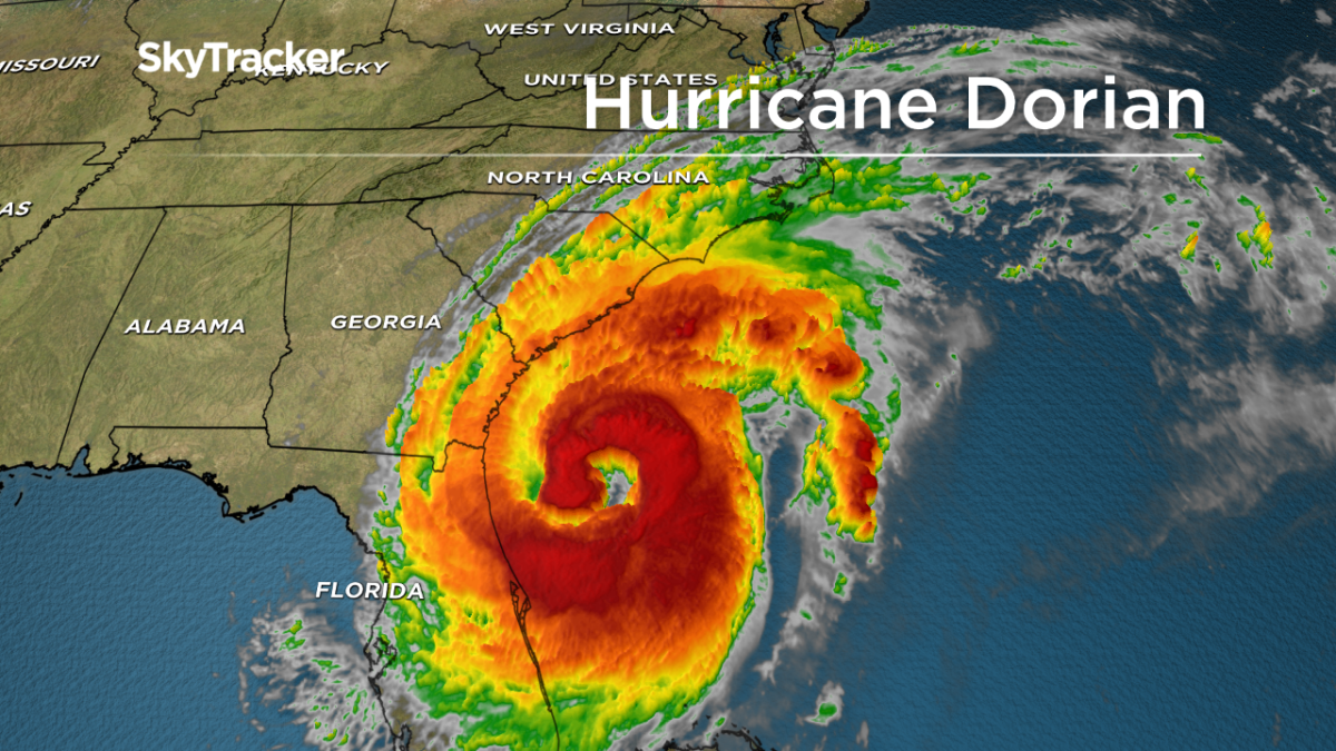
“Hurricane Dorian remains a Category 2 storm today with winds of 165km/h but the size of the system continues to grow,” explained Global News chief meteorologist Anthony Farnell. “There has not been any major change in the track of the storm with significant impacts still expected in South and North Carolina through Friday.”
While there have been no reports of major damage in Florida, Farnell warns that the risk of storm surge for coastal cities is high.
“Storm surge could locally reach eight feet for coastal areas and up to 200 mm of rain will also be enough to cause freshwater flooding,” he said.
He also said Tuesday that as the storm moves, the strength of the winds is decreasing as the radius of the storm increases.
WATCH: U.S. Coast Guard assists with evacuations in Bahamas after Hurricane Dorian hit

“With the storm basically stalled since Sunday, cooler water has mixed in under the storm, which shut down the rich energy source that a powerful hurricane needs to maintain itself,” he said. “Eye wall replacement cycles (common in hurricanes) have also been occurring, which weaken the maximum winds in the eye wall but also expand out the wind field.”
Earlier this week Dorian pummelled parts of the Bahamas as a Category 5 hurricane, leaving widespread devastation and killing at least seven people. Since then, the storm has been downgraded to a Category 2 and continues to move slowly northeast up the coast of the United States.
The National Weather Service reported peak winds of 169 kph early Wednesday.
From the Bahamas, the storm is predicted to head towards the Carolinas while staying just under 150 kilometres off Florida’s east coast.


The core of Dorian will move dangerously close to the Florida east coast and the Georgia coast through Wednesday night. The centre of Dorian is forecast to move near or over the coast of South Carolina and North Carolina Thursday through Friday morning.
“Now that Dorian is moving again and taping into the much warmer weather of the Gulf Stream, the system will be able to maintain its Category 2 status or even intensify slightly before becoming dangerously close to coastal South and North Carolina later this week,” Farnell said.
By this weekend, Farnell predicts that the storm will impact Atlantic Canada, but adds that it will likely be much weaker by then.
“On Friday, Dorian will get caught up in the westerlies and race towards Atlantic Canada with potential landfall in Nova Scotia Saturday night. Even if Dorian gets downgraded or the centre misses the Maritimes, torrential rain and huge waves are expected this weekend.”
WATCH: Hurricane Dorian Impact

Environment Canada says most parts of Atlantic Canada will experience tropical storm force winds, which exceed 63 kilometres per hour.
The strong winds could cause power outages, and pounding surf is expected in Nova Scotia and Newfoundland.
— With files from the Associated Press and the Canadian Press.
Comments