

It’s looking like a drier spring for B.C., according to the province’s River Forecast Centre.

That likely means a break for the interior after several years of damaging floods, but raises the drought risk for the coming summer, according to forecast centre hydrologist Jonathan Boyd.
WATCH: (Aired: March 15) Looking ahead to fire and flood season for 2019

It comes as the agency releases its key April Snow Survey and Water Supply Bulletin, which it says acts as a “good snapshot of the overall annual snowpack that will provide river runoff for the freshet season.”
The good news: snowpack across the province are at below normal levels, and they’re melting earlier, meaning less chance of spring flooding, Boyd said.
“Snowmelt-related flooding is definitely diminished for this year. There are still a few areas that are close to normal, say the upper Fraser, the North Thompson, the Peace River,” he said.
“But compared to last year, the snowpack is significantly lower and the risk is much lower — the B.C. average being 79 per cent of normal.”
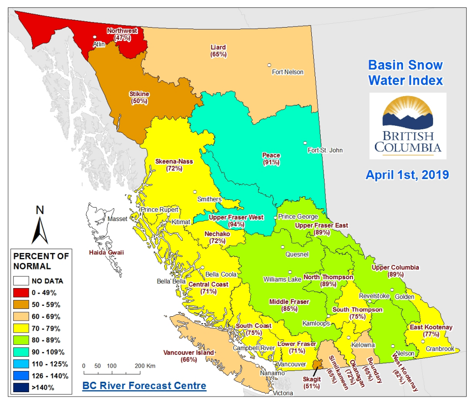
The lowest snowpack is in the northwest, at 47 per cent of normal, while the highest is in the Upper Fraser West, at 94 per cent of normal.
Boyd cautioned that heavy rain events could still bring flooding, but said the province will likely escape the conditions that persisted in 2018, where high snowpack, rapid melt and rain together overwhelmed much of the interior.
“But of course, if the flood risk drops, the drought risk increases.”
Drought concerns
Boyd said while it is still early in the season and conditions could still change drastically, there is “concern” about potential drought conditions cropping up this year.


That is in part because of the lower than usual snowpack and earlier melt, but also because of a particularly dry winter.
He said places like Kelowna, which often get their heaviest rains in May, June and July, could still see concerns offset.
WATCH: Coverage of B.C. floods in Globalnews.ca


However, he said comparisons with conditions in 2015, when B.C. saw one of its worst droughts in recent memory, are not out of the question.
Both years are El Nino years, meaning generally warmer and drier conditions, Boyd added.
READ MORE: ‘The risks related to snow melt are lower’: Below-normal snowpacks in Okanagan dampen flood risks
“We’re definitely better from a snow perceptive, but from how dry it’s been in the last couple months, we’re moving into that territory. The ‘fingers crossed’ is that we’re going to get a few more systems of rain to recharge.”
Boyd said B.C.s northwest, the Okanagan-Similkameen and Vancouver Island could see the greatest drought risk based on current snowpacks.
Comments