
After a long weekend that kicked off with the return to positive temperatures, Family Day Monday started on a cool note with -20 wind chills returning to the valley.

Minus 15 was where the mercury dipped to in the Central Okanagan early in the day, but beautiful blue skies and sunshine got into full swing, helping warm the region into minus single digits by mid-morning.
A slightly cooler day is on the way with a daytime high a few degrees shy of the freezing mark expected under mostly sunny skies Family Day afternoon.
Partly-to-mostly clear conditions overnight will allow the mercury to slip back into minus double-digits once again before clambering back up into the -3 degree range Tuesday as clouds return mid-morning.
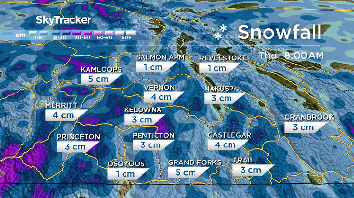
Those clouds will carry some snow, that’s expected to begin sliding in Tuesday afternoon and intensifying into the evening with a few centimetres potentially falling.

The trough generating the snow will linger over the area into Wednesday with a chance of flurries at times before skies clear out and sunshine returns once again on Thursday.


Daytime highs will sit just a few degrees below the freezing mark both days and into Friday as well as another round of clouds and snow sweeps in with the next system.
The final weekend of February is shaping up to be mild with daytime highs pushing back toward the freezing mark under mostly cloudy skies with a chance of flurries.

For weather on the go download the Global News SkyTracker Weather App for iPhone, iPad or Android.
Comments