

Snow slides in after the coldest night of 2019 so far.

Snowfall warning
Environment Canada has issued a snowfall warning for the Prince Albert, North Battleford, Melfort, Meadow Lake and Hudson Bay areas for a low pressure system bringing a swath of snow to parts of central Saskatchewan on Wednesday night.
An area of snow will develop in the northwestern grainbelt Wednesday afternoon as the low draws closer with total snowfall amounts generally in the four to eight cm range but some heavier snow bands will bring local snow accumulations over 10 cm in some areas.
Gusty easterly wind may bring some locally poor visibility at times in snow and blowing snow.
For the latest weather alerts download the Global News SkyTracker Weather App for iPhone, iPad or Android.
Saskatoon forecast
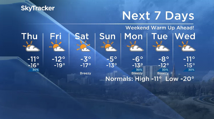
Wednesday
The coldest night the city has seen so far this year slid in Wednesday morning with the mercury plunging back to -25 with wind chills making it feel like -34 at times.
Clouds rolled in to start the day, helping moderate temperatures into the minus teens by daybreak, but a breezy wind kept it feeling close to the -30s until late morning when they warmed to around -27.
Warming continues through Wednesday afternoon as a system pushes in some snow later in the day that could produce a few centimetres in the city as the region climbs to a daytime high around -12 degrees.

Get daily National news
Wednesday night
Three to six centimetres of snow is possible Wednesday night with a breezy wind gusting up to 50 km/h reducing visibility at times as we cool back into the minus teens.
Thursday
Mostly cloudy skies with a slight chance of flurries sticks around through the day on Thursday behind the system swinging through.
-23 is what it’ll feel like with wind chill to start the day before the mercury makes it up to around -11 degrees for an afternoon high with wind chills moderating into them minus teens.

- Thorhild, Westlock counties declare state of agricultural disasters due to rain
- ‘Prolonged stretch of hot air,’ poor air quality advisories blanket the Prairies
- 2 tornadoes touched down in Rocky Mountain House, Environment Canada confirms
- Heavy Nova Scotia rain threatens flooding on anniversary of deadly 2023 flash flood


Friday
Sunshine is slated to return to finish the first full week of 2019 on Friday as an upper ridge starts to build back the heat, the effects of which really won’t be felt until the weekend.
The clear morning will bring in a chilly start to the day, around -19 with wind chills close to -30, but we should warm up to around -12 degrees for an afternoon high.

Weekend outlook
The big warm-up will really be felt this weekend with daytime highs rising into mid-minus single digits both Saturday and Sunday under partly-to-mostly sunny skies.
Shaniya Black took the Your Saskatchewan photo for Jan. 9 in Patuanak:

Saskatoon weather outlook is your source for Saskatoon’s most accurate forecast and is your one stop shop for all things weather for central and northern Saskatchewan with comprehensive, in depth analysis that you can only find here.
For weather on the go download the Global News SkyTracker Weather App for iPhone, iPad or Android.
Comments
Want to discuss? Please read our Commenting Policy first.