
Residents of Vancouver Island are bracing themselves for another heavy storm starting Thursday, which may mean more flooding for a First Nation community near Port Alberni, B.C., as well as other areas of the island.

North, central and western Vancouver Island are expected to be hammered by as much as 100 to 150 millimetres of rain on Thursday night through to Saturday, according to a special weather statement warning issued by Environment Canada.
“Even higher amounts in excess of 150 mm can be expected over the mountains where watersheds are already near capacity,” the statement added.
Then, there will be a brief pause, after which Vancouver Island is expected to be hit by another heavy storm on Sunday, according to Avalanche Canada.
Precipitation on Vancouver Island in October reached record highs, according to an update on flooding preparations from BC Hydro, which said that it would spill as much water as possible from its reservoir through to Thursday afternoon in order to minimize flood risk around the Campbell River watershed.
BC Hydro also advised the public to stay away from the Puntledge and Campbell Rivers over the next week, as both are expected to have very high stream flows.
The Tseshaht First Nation near Port Alberni is maintaining a state of emergency it declared on Nov. 4 as heavy rains battered the region and the Somass River started to rise.
At the time, Tseshaht council member and emergency preparedness committee chair Hugh Braker warned that flooding in the region was expected to match or exceed levels seen in a 2014 flood that was described by residents as “the flood of the century.”
WATCH: The Tseshaht First Nation faces flooding

On Thursday, with even more rain expected in the coming days, Braker said the worst is yet to come.
“The river is full. It’s already flooding. We cannot handle more rain,” he said.

Get breaking National news
Eleven families who were evacuated on the Tseshaht First Nation in the last week have since returned to their homes, but Braker expects they will have to be evacuated again on Saturday. This time, they may be joined by other families.


In addition, the Tseshaht school is closed and a boil water advisory covers about half of the reserve because water lines and sewer lines are underwater.
A boil water advisory has also been in place in the Comox Valley Regional District since Nov. 2 due to high turbidity levels from intense rainfall.
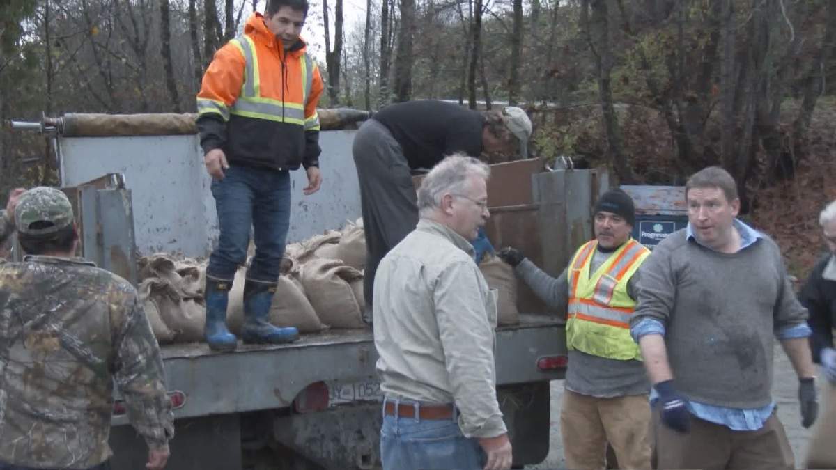
Volunteers have been keeping water at bay in areas near Port Alberni by filling sandbags and hauling them to vulnerable properties, but it is unclear if this will be enough to save homes at risk of flooding in the Tseshaht First Nation.
“I don’t know if we’ll be able to save houses,” said Braker. “We’re trying to redouble our sandbagging efforts, but we don’t know.”
Traffic on Highway 4 was rerouted Wednesday afternoon due to flooding, with the Alberni-Clayoquot Regional District warning motorists to plan for 10 to 20 minutes of additional travel time.
The River Forecast Centre issued flood warnings and advisories for several parts of Vancouver Island on Wednesday afternoon. Campbell River and tributaries and creeks near Port Alberni were placed under a flood warning, while central Vancouver Island, except for Port Alberni, and Courtenay rivers were placed under a flood watch.
The Alberni-Clayoquot Regional District issued a press release Wednesday afternoon encouraging all property owners adjacent to and in low lying areas to take safety measures and make an emergency plan in case flooding occurs. But major flooding of Port Alberni is not expected, it said.
On the mainland, heavy rainfall and snow melt caused the Squamish and Lilloet Rivers to rise rapidly Wednesday night. Parts of Pemberton were shut down with some locals forced to flee their homes, while a high stream flow advisory was issued for the Squamish River near Brackendale.
WATCH: Flooding causes evacuations in Pemberton

The situation improved Thursday afternoon, when the flood advisory for Lilloet River near Pemberton was downgraded to a high streamflow advisory, and a flood watch for Squamish River near Brackendale ended.
The River Forecast Centre also downgraded flood warnings and advisories for some parts of Vancouver Island, including Central Vancouver Island, except for Port Alberni, and the Courtenay rivers, on Thursday afternoon. High stream flow advisories also ended for east, west and north Vancouver Island.
But the centre maintained its flood warning for Campbell River and Somass River, including the Sproat river and surrounding tributaries and creeks near Port Alberni.
With files from Sean Boynton, Kylie Stanton and Yuliya Talmazan.
Comments
Want to discuss? Please read our Commenting Policy first.