

A severe thunderstorm watch has been issued for the Saskatoon, Prince Albert, Kindersley, Rosetown, Biggar, Outlook Watrous areas and into east-central Saskatchewan.

Conditions are favourable for the development of dangerous thunderstorms that could produce damaging wind gusts, large hail and heavy rain.
Environment Canada says to remember that severe thunderstorms can produce tornadoes.
READ MORE: Tornado destroys farm south of Saskatoon
A mid-level disturbance will move towards central Saskatchewan on Thursday afternoon triggering fast moving thunderstorms with some potentially becoming severe.
Very strong wind gusts can damage buildings, down trees and blow large vehicles off the road.
READ MORE: What to do when a tornado touches down in Saskatchewan
In addition, these thunderstorms may be capable of producing strong wind gusts, damaging hail and torrential rain.
For weather on the go download the Global News Skytracker weather app for iPhone, iPad or Android.
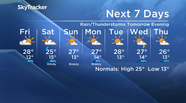
Saskatoon Forecast
Today

Get daily National news
Mostly sunny skies started off the day with temperatures dropping down to 13 degrees overnight.
We warmed into the 20s by mid-morning and into the mid-20s with humidex values making it feel close to 30 degrees by noon.
Clouds are expected to build back in this afternoon with instability and conditions favourable for the development of severe thunderstorms through the remainder of the day with an afternoon high in the high 20s once again and humidex values in the low 30s.
It looks like the majority of the thunderstorm activity will remain north of the city, but there is a chance of some of it swinging through this afternoon.
Tonight
After the thunderstorm risk subsides this evening, clouds will clear back out of the area as the mercury drops back to around 12 degrees overnight.
Friday
Tomorrow looks like it’ll be mostly sunny right into the early afternoon before clouds start to build back in as an area of low pressure at the surface and coupled upper trough move in to destabilize and bring in the clouds.
Temperatures should top out back in the high 20s, feeling like the low 30s with humidity.
Rain and thunderstorms will likely move in during the evening, carrying on at times overnight into early Saturday.
Weekend
Saturday could start off wet with rain and potentially some embedded thunderstorms with the risk tapering off through the day as the low pressure system moves east into Manitoba.
Under mostly cloudy skies it looks like it’ll be a cooler day with an afternoon high trying to make it into the mid-20s.
Sunday we get a ridge building back in aloft that’ll clear skies back out and give us another warm, sunny day with temperatures back into the mid-to-high 20s by afternoon.
Work Week Outlook
The upper ridge looks like it’s going to stick around for the work week, keeping daytime highs in the mid-to-high 20s and partly to mostly sunny skies with a chance of thunderstorms for a few of the days.
This Your Saskatchewan photo was taken by Patricia Warlet Caldeira at Waskesiu Lake:

Saskatoon weather outlook is your one stop shop for all things weather for Saskatoon, central and northern Saskatchewan with a comprehensive, detailed look at your local forecast that you can only find here.


Comments
Want to discuss? Please read our Commenting Policy first.