

Severe thunderstorms ripped through western and central Saskatchewan Sunday night leaving a swath of damage in their wake.

Wind gusts of up to 98 kilometres and hour in Kindersley left a path of destruction with downed power lines reported in the area, along with reports of a roof collapse at the Canalta Hotel.

READ MORE: Tornado touchdown likely west of Saskatoon on Canada Day
Trees were knocked down in Spiritwood, Loreburn and Outlook and grain bins were damaged by wind in the Davidson area.

Last Mountain reported a wind gust of 107 km/h, while North Battleford clocked gusts of 94 km/h.
READ MORE: What to do when a tornado touches down in Saskatchewan
Baseball sized hail was reported in Kindersley, Eston and Smiley and heavy rain caused localized flooding in a number of areas across the region.

For weather on the go download the Global News Skytracker weather app for iPhone, iPad or Android.
Saskatoon Forecast
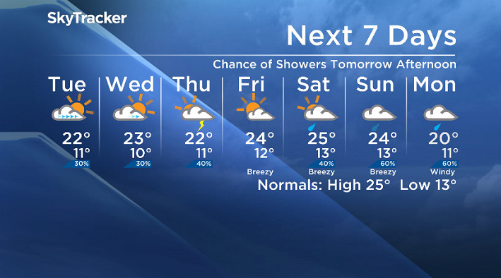
Today
After last night’s thunderstorms picked Saskatoon’s wind gusts up to 75 km/h, we’ve calmed down significantly today.
Temperatures started out around 12 degrees before warming into the low 20s by early afternoon.
Partly to mostly cloudy skies are dominating the day with a very slight chance of a stray shower later on.
Tonight
Partly to mostly cloudy skies will continue tonight as the mercury drops back to around 11 degrees.
Tuesday
A mix of sun and cloud will start off the day tomorrow before clouds build back in midday with a slight chance of a late day shower in the area.

Temperatures will rise up to around 22 degrees in the afternoon with humidity making it feel a few degrees warmer.
Wednesday-Friday
Increasing cloudiness is also expected on Wednesday with a chance of late day showers.
There’s a better chance of showers on Thursday with a weak upper low swinging through before some weak upper level ridging moves in for Friday helping to bring back some more sunshine.
Daytime highs are likely to remain in the low-to-mid 20s through the end of the week.
Weekend Outlook
At this point it looks as though there’s a good chance of showers or thunderstorms on Saturday and most models are bringing in an upper low later in the weekend that is likely to bring in some steadier rain Sunday into early next week.
There’s more discrepancy in temperatures over the weekend with daytime highs at this point likely to be in the mid-20s both days before cooling off into early next week.
Brandi Sankey took this Your Saskatchewan photo near Lloydminster:

Saskatoon weather outlook is your one stop shop for all things weather for Saskatoon, central and northern Saskatchewan with a comprehensive, detailed look at your local forecast that you can only find here.
Comments