

Satellite data released today by NASA paints a detailed and sinister portrait of wildfires closing in on Fort McMurray early this morning.

The NASA data shows the wildfire closing in on Fort McMurray from the south and west, invading the Abasand, Beacon Hill and Waterways neighbourhoods.
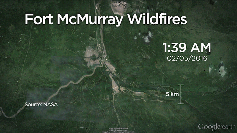
This loop image shows the last 96 hours of the Fort McMurray fire. (Updated May 6.)
Alberta Premier Rachel Notley said roughly 1,600 structures in Fort McMurray have destroyed or damaged by a wildfire that raged through Fort McMurray Tuesday night, Global News reported.
In a news conference Wednesday morning, Notley said depending on the wind, the fire likely will spread into the Thickwood and Timberlea neighbourhoods. The fire is expected to be even worse than on Tuesday, thanks to a third day of high temperatures and low humidity. The current size is between 7,500 and 10,000 hectares.

Get daily National news
About 88,000 people have fled the fire.
Click on any point in the interactive map below for details. Time stamps in the data are in Coordinated Universal Time (or Greenwich Mean Time). Deduct six hours for Mountain Time.
The map points are accurate to within 375 metres. It was last updated at 4:15 a.m. (MT). NASA gathers data on wildfires across the world through a system of satellites.

READ MORE: In-depth coverage of the Fort McMurray wildfire

Chad Morrison, Senior Manager of Wildfire Prevention with the Government of Alberta, says the wildfire in and near Fort McMurray is expected to be even worse Wednesday than it was Tuesday, when it swept into the Alberta community and laid waste to multiple neighbourhoods.

-
![]() Fort McMurray wildfire: A timeline of a disaster
Fort McMurray wildfire: A timeline of a disaster -
![]() Incredible footage takes us inside the fight against the Fort McMurray wildfire
Incredible footage takes us inside the fight against the Fort McMurray wildfire -
![]() PTSD in first responders a concern as Fort McMurray wildfires continue: Experts
PTSD in first responders a concern as Fort McMurray wildfires continue: Experts -
![]() Fort McMurray Wildfire: East Coast musicians raising money for Fort McMurray relief
Fort McMurray Wildfire: East Coast musicians raising money for Fort McMurray relief -
![]() Fort McMurray Wildfire: Families reunited in Moncton
Fort McMurray Wildfire: Families reunited in Moncton -
![]() Fort McMurray Wildfire: Resident flees as fire surrounds him
Fort McMurray Wildfire: Resident flees as fire surrounds him -
![]() Fort McMurray Wildfire: Wildrose leader says 80% of Fort McMurray is OK In an interview Friday
Fort McMurray Wildfire: Wildrose leader says 80% of Fort McMurray is OK In an interview Friday -
![]() Canadian Red Cross updates Fort McMurray wildfire situation Friday
Canadian Red Cross updates Fort McMurray wildfire situation Friday -
![]() Fort McMurray man watches his own home burn down via doorbell camera
Fort McMurray man watches his own home burn down via doorbell camera -
![]() ‘We’ll get through it’: Emotional Ambrose proud to see Alberta support Fort McMurray evacuees
‘We’ll get through it’: Emotional Ambrose proud to see Alberta support Fort McMurray evacuees -
![]() Cause of Fort McMurray wildfire still under investigation, says Alberta fire prevention team
Cause of Fort McMurray wildfire still under investigation, says Alberta fire prevention team -
![]() ‘We are absolutely, eternally grateful’: Mayor of Fort McMurray gives emotional thank you speech
‘We are absolutely, eternally grateful’: Mayor of Fort McMurray gives emotional thank you speech -
![]() ‘The fire continues to burn out of control’: Fort McMurray wildfire grows to 101,000 hectares
‘The fire continues to burn out of control’: Fort McMurray wildfire grows to 101,000 hectares -
![]() Psychological impact on Fort McMurray evacuees a focus of emergency services
Psychological impact on Fort McMurray evacuees a focus of emergency services -
![]() ‘Apocolyptic’: Southbound evacuees describe destruction in Fort McMurray
‘Apocolyptic’: Southbound evacuees describe destruction in Fort McMurray -
![]() Justin Trudeau explains why he isn’t planning to visit Fort McMurray until the fire is under control
Justin Trudeau explains why he isn’t planning to visit Fort McMurray until the fire is under control -
![]() Prime Minister Trudeau says federal government has offered all assistance in dealing with Fort McMurray fire
Prime Minister Trudeau says federal government has offered all assistance in dealing with Fort McMurray fire -
![]() Fire crews drop retardant on Fort McMurray wildfires
Fire crews drop retardant on Fort McMurray wildfires -
![]() Fort McMurray resident shares security video moments before home is engulfed in flames
Fort McMurray resident shares security video moments before home is engulfed in flames -
![]() Evacuee driving through Fort McMurray captures images of scorched earth
Evacuee driving through Fort McMurray captures images of scorched earth


Comments
Want to discuss? Please read our Commenting Policy first.